IMAGES TAKEN NEAR TO
North Street, FAVERSHAM, ME13 0LN
Introduction
This page details the photographs taken nearby to North Street, ME13 0LN by members of the Geograph project.
The Geograph project started in 2005 with the aim of publishing, organising and preserving representative images for every square kilometre of Great Britain, Ireland and the Isle of Man.

There are currently over 7.5m images from over14,400 individuals and you can help contribute to the project by visiting https://www.geograph.org.uk
Image Map
Images are licensed for reuse under creativecommons.org/licenses/by-sa/2.0
Notes
- Clicking on the map will re-center to the selected point.
- The higher the marker number, the further away the image location is from the centre of the postcode.
Image Listing (10 Images Found)
Images are licensed for reuse under creativecommons.org/licenses/by-sa/2.0
Image
Details
Distance
1
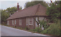
Old Toll House by Ashford Road, North Street
Toll House in the parish of Sheldwich (Shepway District), Tollgate House, North Street (A251).
Grade II listed.
List Entry Number: 1363413 https://historicengland.org.uk/listing/the-list/list-entry/1363413
To be surveyed
Milestone Society National ID: KE.SHE
Image: © Milestone Society
Taken: Unknown
0.07 miles
2
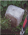
Old Milestone by the A251, Ashford Road, North Street, Sheldwich parish
Stone post (plate lost) by the A251, in parish of SHELDWICH (SWALE District), Ashford Road, North Street, by "Tollgate House", opposite Harewell Cottage, beside road in undergrowth by cottage, on West side of road. Faversham iron plate, erected by the Faversham to Hythe & Canterbury turnpike trust in the 19th century.
Inscription once read:-
(FAVERSHAM)
(2 MILES)
(ASHFORD)
(11 MILES)
Carved benchmark on top.
Grade II listed.
List Entry Number: 1069899 https://historicengland.org.uk/listing/the-list/list-entry/1069899
Milestone Society National ID: KE_FVAF02.
Image: © C Woodward
Taken: 17 Jul 2008
0.07 miles
3
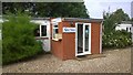
Business Units in Rural Setting
The fast A251 road runs through North Street Village. The Units are next to the main road.
Image: © James Emmans
Taken: 12 Jul 2014
0.09 miles
6
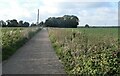
Footpath, North Street, near Sheldwich
The path runs between Ashford Road and Plumford Road. Littles Manor Farm is ahead.
Image: © pam fray
Taken: 3 Nov 2021
0.17 miles
7
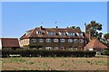
Littles Manor Farm road
This road leads from the Farm and Manor House to the A251 Ashford Road. A footpath also uses this road leading from Plumford Road.
Image: © David Anstiss
Taken: 24 Jun 2009
0.17 miles
8
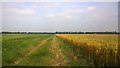
Kent Farmland
Rural area with large fields of wheat as seen from a bridleway.
Image: © James Emmans
Taken: 12 Jul 2014
0.17 miles
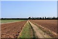
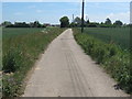
10

Bridleway to Gosmere
This bridleway leads from A251 Ashford Road, past Gosmere Farm to Owens Court Lane.
Image: © David Anstiss
Taken: 24 Jun 2009
0.20 miles