IMAGES TAKEN NEAR TO
Wyebanks Road, FAVERSHAM, ME13 0DA
Introduction
This page details the photographs taken nearby to Wyebanks Road, ME13 0DA by members of the Geograph project.
The Geograph project started in 2005 with the aim of publishing, organising and preserving representative images for every square kilometre of Great Britain, Ireland and the Isle of Man.

There are currently over 7.5m images from over14,400 individuals and you can help contribute to the project by visiting https://www.geograph.org.uk
Image Map
Images are licensed for reuse under creativecommons.org/licenses/by-sa/2.0
Notes
- Clicking on the map will re-center to the selected point.
- The higher the marker number, the further away the image location is from the centre of the postcode.
Image Listing (4 Images Found)
Images are licensed for reuse under creativecommons.org/licenses/by-sa/2.0
Image
Details
Distance
1
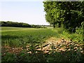
Wheat field
Looking north to the edge of the square and beyond from the Wyebanks Road.
Image: © Penny Mayes
Taken: 8 Jun 2006
0.19 miles
2
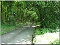
Hurstwood Lane
Running southish through Sparks Wood, part of the Otterden Estate, from the Wyebanks Road.
Image: © Penny Mayes
Taken: 8 Jun 2006
0.20 miles
3
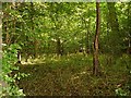
Sparks Wood
Near Wyebanks, part of the Otterden estate. Shame I missed the bluebells...
Image: © Penny Mayes
Taken: 8 Jun 2006
0.20 miles
4
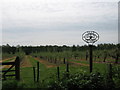
Seed Orchard
This orchard is on Seed Road, near Wellwood Farm. Has attractive metal 'cut-out' sign.
Image: © David Anstiss
Taken: 10 May 2009
0.25 miles