IMAGES TAKEN NEAR TO
City Way, ROCHESTER, ME1 2AU
Introduction
This page details the photographs taken nearby to City Way, ME1 2AU by members of the Geograph project.
The Geograph project started in 2005 with the aim of publishing, organising and preserving representative images for every square kilometre of Great Britain, Ireland and the Isle of Man.

There are currently over 7.5m images from over14,400 individuals and you can help contribute to the project by visiting https://www.geograph.org.uk
Image Map (Loading...)


Getting Data...Please wait
Leaflet Map data © OpenStreetMap
Images are licensed for reuse under creativecommons.org/licenses/by-sa/2.0
Notes
- Clicking on the map will re-center to the selected point.
- The higher the marker number, the further away the image location is from the centre of the postcode.
Image Listing (92 Images Found)
Images are licensed for reuse under creativecommons.org/licenses/by-sa/2.0
Image
Details
Distance
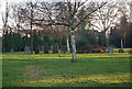
2
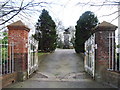
Entrance to Fort Pitt Military Cemetery, Rochester
Image: © Chris Whippet
Taken: 18 Mar 2014
0.03 miles
4
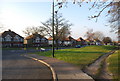
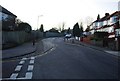
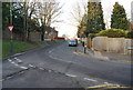
Grassy area at the junction of City Way, A229 & Old Patten Lane
Image: © N Chadwick
Taken: 31 Jan 2009
0.03 miles
5
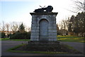
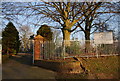
Memorial, Fort Pitt Military Cemetery
http://www.rossfamily.plus.com/historicmedway/chatham/fortpittmilitarycemetery.htm
Image: © N Chadwick
Taken: 31 Jan 2009
0.05 miles
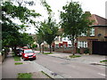
9
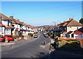
Boundary Road, Chatham
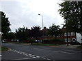
View down Boundary Road, from the corner of The Chase, Chatham.
Image: © Thomas Beilby
Taken: 16 Feb 2008
0.09 miles