IMAGES TAKEN NEAR TO
City Way, ROCHESTER, ME1 2AE
Introduction
This page details the photographs taken nearby to City Way, ME1 2AE by members of the Geograph project.
The Geograph project started in 2005 with the aim of publishing, organising and preserving representative images for every square kilometre of Great Britain, Ireland and the Isle of Man.

There are currently over 7.5m images from over14,400 individuals and you can help contribute to the project by visiting https://www.geograph.org.uk
Image Map
Images are licensed for reuse under creativecommons.org/licenses/by-sa/2.0
Notes
- Clicking on the map will re-center to the selected point.
- The higher the marker number, the further away the image location is from the centre of the postcode.
Image Listing (110 Images Found)
Images are licensed for reuse under creativecommons.org/licenses/by-sa/2.0
Image
Details
Distance
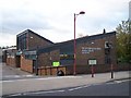
2
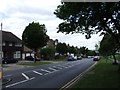
Mid Kent College, City Way Centre, City Way
Mid Kent College has centres in Maidstone, Chatham & Rochester.
Image: © N Chadwick
Taken: 31 Jan 2009
0.04 miles

8
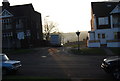
St. Peter's Church, Rochester
On Delce Road, beside Rochester Health Centre.
Image: © David Anstiss
Taken: 12 Nov 2008
0.09 miles
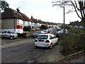
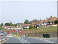
9

Don Cossack, Rochester
This old pub is now the Jasmine Garden Chinese restaurant.
Image: © Chris Whippet
Taken: 18 Nov 2009
0.09 miles
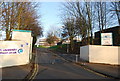
10
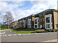
The Fort, Rochester
New residential development built on the site of Fort pitt and later Mid Kent College.
Image: © Chris Whippet
Taken: 18 Mar 2014
0.09 miles