IMAGES TAKEN NEAR TO
Roebuck Road, ROCHESTER, ME1 1UD
Introduction
This page details the photographs taken nearby to Roebuck Road, ME1 1UD by members of the Geograph project.
The Geograph project started in 2005 with the aim of publishing, organising and preserving representative images for every square kilometre of Great Britain, Ireland and the Isle of Man.

There are currently over 7.5m images from over14,400 individuals and you can help contribute to the project by visiting https://www.geograph.org.uk
Image Map
Images are licensed for reuse under creativecommons.org/licenses/by-sa/2.0
Notes
- Clicking on the map will re-center to the selected point.
- The higher the marker number, the further away the image location is from the centre of the postcode.
Image Listing (393 Images Found)
Images are licensed for reuse under creativecommons.org/licenses/by-sa/2.0
Image
Details
Distance
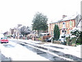
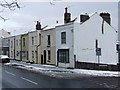
3
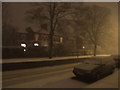
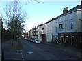
Snowfall over Maidstone Road, Rochester
Image: © Chris Whippet
Taken: 17 Dec 2009
0.05 miles
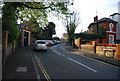
8
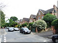
Watt's Avenue, Rochester
Watt's Avenue is named after Richard Watts, MP for Rochester in the 1570s, who left money in his will for local charitable purposes. The houses here are mainly substantial semi-detached mansions although down the hill across Maidstone Road is the Troy Town area where the properties are smaller.
Image: © Stephen McKay
Taken: 22 Oct 2021
0.06 miles
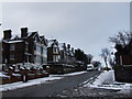
10
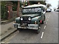
Vintage 1955 Land Rover, Watts Avenue, Rochester
Image: © Chris Whippet
Taken: 12 Dec 2015
0.07 miles