IMAGES TAKEN NEAR TO
George Lane, ROCHESTER, ME1 1NW
Introduction
This page details the photographs taken nearby to George Lane, ME1 1NW by members of the Geograph project.
The Geograph project started in 2005 with the aim of publishing, organising and preserving representative images for every square kilometre of Great Britain, Ireland and the Isle of Man.

There are currently over 7.5m images from over14,400 individuals and you can help contribute to the project by visiting https://www.geograph.org.uk
Image Map
Images are licensed for reuse under creativecommons.org/licenses/by-sa/2.0
Notes
- Clicking on the map will re-center to the selected point.
- The higher the marker number, the further away the image location is from the centre of the postcode.
Image Listing (1200 Images Found)
Images are licensed for reuse under creativecommons.org/licenses/by-sa/2.0
Image
Details
Distance
1
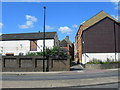
George Lane, Rochester
Photo taken from across Corporation Street. The site on the left is derelict, to the right there are some apartments.
Image: © Danny P Robinson
Taken: 13 Jul 2008
0.01 miles
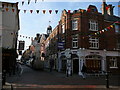
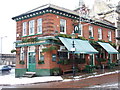
2
The Jolly Knight and Turks Head Public Houses, High Street, Rochester
Image: © Bill Henderson
Taken: 12 Feb 2017
0.01 miles
4
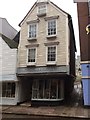
Henderson's shop, High Street, Rochester
This quaint wooden fronted shop sells crockery, ornaments , small items of household furniture etc.
Image: © Bill Henderson
Taken: 12 Feb 2017
0.02 miles
6
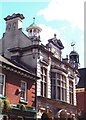
Impressive Regency building in Rochester High Street
I particularly like the large weather vane on the right hand cupola, also the Dutch and classical influences at work here too.
Image: © Jonathon Stenner
Taken: 7 Apr 2006
0.02 miles
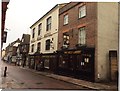
7
Expectations, Rochester
Previously known as the White Hart.
Image: © Chris Whippet
Taken: 18 Dec 2009
0.03 miles
8
Granite setts in a pavement, Corporation Street (A2)
The wording of the plaque, attached to the wall above the pavement, is that “the line of granite setts laid in the footway denotes the limit of the old Roman city wall which still exists some few feet below the footway surface”.
Image: © John Baker
Taken: 24 Nov 2014
0.03 miles
9
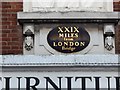
Old Milestone by #25, Rochester High Street
Carved stone plaque by the UC road, in parish of ROCHESTER (MEDWAY District), High Street, on No. 25, North of George Lane, above facia of shop, under window, on East side of road. Erected by the Dartford & Strood turnpike trust in the 19th century.
Inscription reads:-
XXIX
MILES
from
LONDON
BRIDGE
Milestone Society National ID: KE_LD29.
Image: © C Woodward
Taken: 22 Feb 2009
0.03 miles