IMAGES TAKEN NEAR TO
Doust Way, ROCHESTER, ME1 1FG
Introduction
This page details the photographs taken nearby to Doust Way, ME1 1FG by members of the Geograph project.
The Geograph project started in 2005 with the aim of publishing, organising and preserving representative images for every square kilometre of Great Britain, Ireland and the Isle of Man.

There are currently over 7.5m images from over14,400 individuals and you can help contribute to the project by visiting https://www.geograph.org.uk
Image Map
Images are licensed for reuse under creativecommons.org/licenses/by-sa/2.0
Notes
- Clicking on the map will re-center to the selected point.
- The higher the marker number, the further away the image location is from the centre of the postcode.
Image Listing (324 Images Found)
Images are licensed for reuse under creativecommons.org/licenses/by-sa/2.0
Image
Details
Distance
1
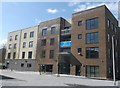
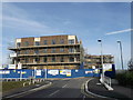
Building, Rochester Riverside
One of the newly constructed Hyde Housing shared ownership buildings, part of the new development on Doust Way.
Image: © David Anstiss
Taken: 29 Mar 2013
0.01 miles
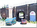
2
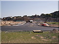
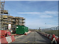
Tarmacking the new road in Rochester Riverside (2)
A road (and accompanying drainage) has been extended into Rochester Riverside from Doust Way, near Rochester High Street. This is the first phase of the large development on land in Rochester.
This road will be followed by the building of 73 new rental and
shared ownership flats (eitherside of the road) and one commercial unit, constructed by Denne Construction for Hyde Housing.
Image: © David Anstiss
Taken: 1 Sep 2011
0.01 miles
3
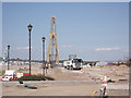
Tarmacking the new road in Rochester Riverside
A road (and accompanying drainage) is being extended into Rochester Riverside. This is the first phase of the large development on land in Rochester.
This road will be followed by the building of 73 new rental and
shared ownership flats and one commercial unit by Denne Construction.
In the background is Image
The yellow crane is Image
Image: © David Anstiss
Taken: 1 Sep 2011
0.01 miles
4
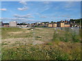
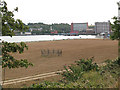
Development Land at Rochester Riverside
As seen from Doust Way.
Image: © David Anstiss
Taken: 16 Jun 2013
0.01 miles
5
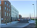
Doust Way, Rochester Riverside
This new road extends into the large development site beside the River Medway.
Several blocks of housing are being built currently.
Image: © David Anstiss
Taken: 30 Sep 2012
0.01 miles
7
New houses on Doust Way, Rochester Riverside
These two blocks of houses are the first part of the major development of Rochester Riverside.
Image: © David Anstiss
Taken: 30 Sep 2012
0.02 miles
8
Development land by the Medway
This strip of land between Rochester station and the river appears to have been cleared quite recently of whatever buildings were there before. I expect that an 'exclusive' housing development will follow.
Image: © Stephen Craven
Taken: 31 Aug 2009
0.02 miles
10
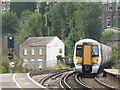
New railway signal at Rochester
This is an enlargement of part of Image
The signal is dated 2008 and numbered ER8. Another contributor explains this code as follows: "E means Eastern section of the Southern. R is the next letter free. A was at the London end and the next 'box was B. So, Chatham was ES and Gillingham still is ET etc."
Image: © Stephen Craven
Taken: 31 Aug 2009
0.04 miles