IMAGES TAKEN NEAR TO
Fort Pitt, ROCHESTER, ME1 1DZ
Introduction
This page details the photographs taken nearby to Fort Pitt, ME1 1DZ by members of the Geograph project.
The Geograph project started in 2005 with the aim of publishing, organising and preserving representative images for every square kilometre of Great Britain, Ireland and the Isle of Man.

There are currently over 7.5m images from over14,400 individuals and you can help contribute to the project by visiting https://www.geograph.org.uk
Image Map
Images are licensed for reuse under creativecommons.org/licenses/by-sa/2.0
Notes
- Clicking on the map will re-center to the selected point.
- The higher the marker number, the further away the image location is from the centre of the postcode.
Image Listing (291 Images Found)
Images are licensed for reuse under creativecommons.org/licenses/by-sa/2.0
Image
Details
Distance
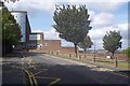
2
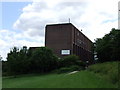
University of Creative Arts, Rochester
Image: © Chris Whippet
Taken: 19 Jun 2009
0.01 miles
3
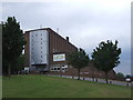
University for the Creative Arts, Rochester
Image: © Chris Whippet
Taken: 9 Jun 2009
0.02 miles
4
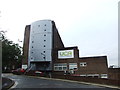
University of Creative Arts, Rochester
Image: © Chris Whippet
Taken: 16 Oct 2013
0.02 miles
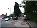
6
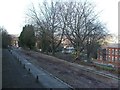
Fort Pitt Hill road leading to UCA
Fort Pitt Hill road leads up from the A2 New Road past the University for the Creative Arts, Rochester, then back down to the road.
Image: © David Anstiss
Taken: 2 Jan 2009
0.03 miles
7
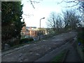
Unadopted road, Rochester
This unmade road leads from New Road up to Fort Pitt Hill and is primarily used for parking by the University for the Creative Arts.
Image: © Chris Whippet
Taken: 9 Jun 2009
0.04 miles