IMAGES TAKEN NEAR TO
New Road, ROCHESTER, ME1 1DX
Introduction
This page details the photographs taken nearby to New Road, ME1 1DX by members of the Geograph project.
The Geograph project started in 2005 with the aim of publishing, organising and preserving representative images for every square kilometre of Great Britain, Ireland and the Isle of Man.

There are currently over 7.5m images from over14,400 individuals and you can help contribute to the project by visiting https://www.geograph.org.uk
Image Map
Images are licensed for reuse under creativecommons.org/licenses/by-sa/2.0
Notes
- Clicking on the map will re-center to the selected point.
- The higher the marker number, the further away the image location is from the centre of the postcode.
Image Listing (329 Images Found)
Images are licensed for reuse under creativecommons.org/licenses/by-sa/2.0
Image
Details
Distance
3

Wasteland by the Railway, Rochester
Image: © Danny P Robinson
Taken: 15 Jun 2008
0.03 miles
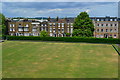
6
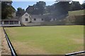
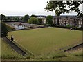
Cranborne Bowling Green, Chatham
Part of the Jackson's Field Recreational area on New Road.
Image: © David Anstiss
Taken: 11 Sep 2009
0.04 miles
9
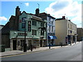
Pub, Restaurant and Shops, Rochester High Street
Showing the North Foreland, the Limehouse Thai and a barbers shop. Plus a CCTV camera in front of the pub.
Image: © Danny P Robinson
Taken: 13 Jul 2008
0.06 miles
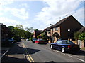
10
Passageway between New Covenant Place and New Road, Rochester
Image: © Chris Whippet
Taken: 9 Jun 2009
0.06 miles