IMAGES TAKEN NEAR TO
Hawkins Close, MANCHESTER, M9 8QH
Introduction
This page details the photographs taken nearby to Hawkins Close, M9 8QH by members of the Geograph project.
The Geograph project started in 2005 with the aim of publishing, organising and preserving representative images for every square kilometre of Great Britain, Ireland and the Isle of Man.

There are currently over 7.5m images from over14,400 individuals and you can help contribute to the project by visiting https://www.geograph.org.uk
Image Map
Images are licensed for reuse under creativecommons.org/licenses/by-sa/2.0
Notes
- Clicking on the map will re-center to the selected point.
- The higher the marker number, the further away the image location is from the centre of the postcode.
Image Listing (9 Images Found)
Images are licensed for reuse under creativecommons.org/licenses/by-sa/2.0
Image
Details
Distance
1
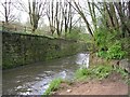
River Irk, Crumpsall, Manchester
This river rises close to Royton, Oldham and joins the River Irwell in central Manchester, near the Cathedral. Its course here has been "helped" by man. The area it flows through has been heavily industrialised in the past.
Image: © Keith Williamson
Taken: 7 Apr 2005
0.02 miles
2
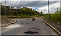
Blackley
The site of the ICI Blackley Works, now wasteland awaiting development of a new housing estate.
Image: © Peter McDermott
Taken: 3 May 2015
0.06 miles
3
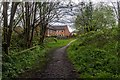
Irk Valley
Path alongside the River Irk near Blackley.
Image: © Peter McDermott
Taken: 3 May 2015
0.11 miles
4

River Irk, Crumpsall, Manchester
This river has its source near Royton, Oldham and joins the River Irwell in central Manchester, near the Cathedral.
Image: © Keith Williamson
Taken: 7 Apr 2005
0.20 miles
5
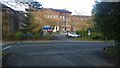
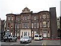
Towards the Pennine Trust Headquarters
Looking from Central Drive towards the Headquarters of the Pennine Acute Hospitals NHS Trust, located in Crumpsall in north Manchester, England.
Image: © Steven Haslington
Taken: 11 Jan 2016
0.20 miles
7
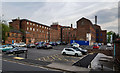
North Manchester General Hospital
Buildings on the NMGH site.
Image: © Peter McDermott
Taken: 20 May 2018
0.24 miles
8
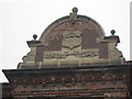
Workhouse Infirmary, Crumpsall, Manchester
Some of today's hospital buildings were once the workhouse infirmary. Above one entrance is this stonework, from the infirmary days. It shows the Manchester coat of arms with an inscription: "Poor and needy - the Lord careth for me." It is still in place above one of the entrances on Central Drive at North Manchester General Hospital.
Image: © Tricia Neal
Taken: 4 Nov 2011
0.24 miles
9
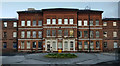
The Workhouse Infirmary, off Delaunays Road
Built in 1876 as an Infirmary for the new Manchester Workhouse. The carpark area was originally gardens. Taken from Central Drive, North Manchester General Hospital.
Other views of North Manchester General Hospital are at http://www.geograph.org.uk/photo/3742962
Image: © Tricia Neal
Taken: 4 Nov 2011
0.25 miles