IMAGES TAKEN NEAR TO
Sandyhill Road, MANCHESTER, M9 8HS
Introduction
This page details the photographs taken nearby to Sandyhill Road, M9 8HS by members of the Geograph project.
The Geograph project started in 2005 with the aim of publishing, organising and preserving representative images for every square kilometre of Great Britain, Ireland and the Isle of Man.

There are currently over 7.5m images from over14,400 individuals and you can help contribute to the project by visiting https://www.geograph.org.uk
Image Map
Images are licensed for reuse under creativecommons.org/licenses/by-sa/2.0
Notes
- Clicking on the map will re-center to the selected point.
- The higher the marker number, the further away the image location is from the centre of the postcode.
Image Listing (13 Images Found)
Images are licensed for reuse under creativecommons.org/licenses/by-sa/2.0
Image
Details
Distance
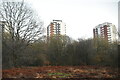
2
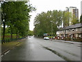
Towerblocks from Blackley New Road
Towerblocks in North Manchester, as seen from Blackley New Road.
Image: © Steven Haslington
Taken: 28 Mar 2018
0.22 miles
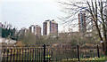
7
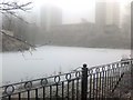
King William IV Fishing Pond Blackley New Road.
Locally known as the Bottom Billy, and is well stocked with coarse fish.
Photo was taken on New Year's Eve 2008 in freezing fog, temperature was -4.
Image: © Ray West
Taken: 31 Dec 2008
0.24 miles
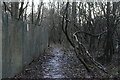
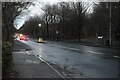
8
Chapel Lane, Manchester
Looking north west.
Image: © JThomas
Taken: 17 Sep 2018
0.24 miles
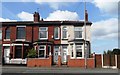
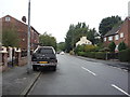
10
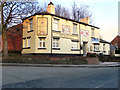
The Pleasant
"The Pleasant", a public house at the corner of Crab Lane and Chapel Lane, Higher Blackley.
Image: © David Dixon
Taken: 8 Feb 2011
0.25 miles