IMAGES TAKEN NEAR TO
Bromfield Avenue, MANCHESTER, M9 8AG
Introduction
This page details the photographs taken nearby to Bromfield Avenue, M9 8AG by members of the Geograph project.
The Geograph project started in 2005 with the aim of publishing, organising and preserving representative images for every square kilometre of Great Britain, Ireland and the Isle of Man.

There are currently over 7.5m images from over14,400 individuals and you can help contribute to the project by visiting https://www.geograph.org.uk
Image Map
Images are licensed for reuse under creativecommons.org/licenses/by-sa/2.0
Notes
- Clicking on the map will re-center to the selected point.
- The higher the marker number, the further away the image location is from the centre of the postcode.
Image Listing (6 Images Found)
Images are licensed for reuse under creativecommons.org/licenses/by-sa/2.0
Image
Details
Distance
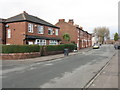
1
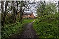
Irk Valley
Path alongside the River Irk near Blackley.
Image: © Peter McDermott
Taken: 3 May 2015
0.12 miles
2
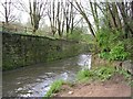
River Irk, Crumpsall, Manchester
This river rises close to Royton, Oldham and joins the River Irwell in central Manchester, near the Cathedral. Its course here has been "helped" by man. The area it flows through has been heavily industrialised in the past.
Image: © Keith Williamson
Taken: 7 Apr 2005
0.17 miles
3
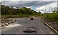
Blackley
The site of the ICI Blackley Works, now wasteland awaiting development of a new housing estate.
Image: © Peter McDermott
Taken: 3 May 2015
0.18 miles
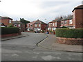
6
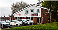
The Alliance Inn
The Alliance Inn public house.
Image: © Peter McDermott
Taken: 17 Oct 2014
0.24 miles