IMAGES TAKEN NEAR TO
Lowbrook Avenue, MANCHESTER, M9 7JD
Introduction
This page details the photographs taken nearby to Lowbrook Avenue, M9 7JD by members of the Geograph project.
The Geograph project started in 2005 with the aim of publishing, organising and preserving representative images for every square kilometre of Great Britain, Ireland and the Isle of Man.

There are currently over 7.5m images from over14,400 individuals and you can help contribute to the project by visiting https://www.geograph.org.uk
Image Map
Images are licensed for reuse under creativecommons.org/licenses/by-sa/2.0
Notes
- Clicking on the map will re-center to the selected point.
- The higher the marker number, the further away the image location is from the centre of the postcode.
Image Listing (14 Images Found)
Images are licensed for reuse under creativecommons.org/licenses/by-sa/2.0
Image
Details
Distance
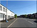
2
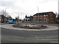
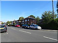
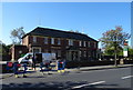
Fourways Roundabout
The block of flats on the right marks the approximate site of the Fourways Cinema, well known (or perhaps notorious) for Saturday children's matinee showings in the 1960s.
Image: © Peter Whatley
Taken: 20 Jan 2010
0.12 miles
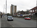
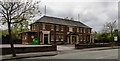
6
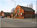
The Methodist Church, Chain Bar
Methodist Church on the corner of Nina Drive with Moston Lane.
Image: © David Dixon
Taken: 9 Apr 2010
0.22 miles
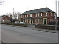
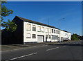
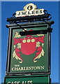
8
The Charlestown public house
On Charlestown Road.
Image: © JThomas
Taken: 25 Sep 2018
0.22 miles
9
The Charlestown
The Charlestown public house on Charlestown Road in Charlestown.
Image: © Peter McDermott
Taken: 1 May 2017
0.22 miles