IMAGES TAKEN NEAR TO
Capricorn Road, MANCHESTER, M9 7JA
Introduction
This page details the photographs taken nearby to Capricorn Road, M9 7JA by members of the Geograph project.
The Geograph project started in 2005 with the aim of publishing, organising and preserving representative images for every square kilometre of Great Britain, Ireland and the Isle of Man.

There are currently over 7.5m images from over14,400 individuals and you can help contribute to the project by visiting https://www.geograph.org.uk
Image Map
Images are licensed for reuse under creativecommons.org/licenses/by-sa/2.0
Notes
- Clicking on the map will re-center to the selected point.
- The higher the marker number, the further away the image location is from the centre of the postcode.
Image Listing (4 Images Found)
Images are licensed for reuse under creativecommons.org/licenses/by-sa/2.0
Image
Details
Distance
1
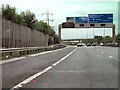
M60 Clockwise
Overhead signs on the Manchester Outer Ring Road (M60) as it passes through Charlestown. Alkirington Golf course is to the left, behind the fence.
Image: © David Dixon
Taken: 20 Jul 2010
0.19 miles
3
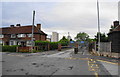
The entrance to Charlestown Primary School
Image: © Bill Boaden
Taken: 7 Jun 2010
0.24 miles
4
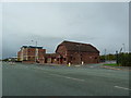
The Toy Box, Victoria Avenue East, Moston
Image: © Alexander P Kapp
Taken: 5 Oct 2011
0.24 miles