IMAGES TAKEN NEAR TO
Plant Hill Road, MANCHESTER, M9 6WH
Introduction
This page details the photographs taken nearby to Plant Hill Road, M9 6WH by members of the Geograph project.
The Geograph project started in 2005 with the aim of publishing, organising and preserving representative images for every square kilometre of Great Britain, Ireland and the Isle of Man.

There are currently over 7.5m images from over14,400 individuals and you can help contribute to the project by visiting https://www.geograph.org.uk
Image Map
Images are licensed for reuse under creativecommons.org/licenses/by-sa/2.0
Notes
- Clicking on the map will re-center to the selected point.
- The higher the marker number, the further away the image location is from the centre of the postcode.
Image Listing (16 Images Found)
Images are licensed for reuse under creativecommons.org/licenses/by-sa/2.0
Image
Details
Distance
1
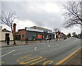
McColl's, Higher Blackley
The store on Victoria Avenue (A6104) was previously a Co-operative store.
Image: © Gerald England
Taken: 26 Jan 2019
0.08 miles
2
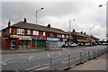
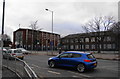
Row of shops on Victoria Avenue
This used to be a well-balanced row of shops, with an award-winning bakery amongst them. It now consists almost entirely of takeaways.
Image: © Bill Boaden
Taken: 13 Mar 2010
0.08 miles
3
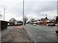
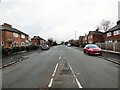
Victoria Avenue
The A6104 through Higher Blackley.
Image: © Gerald England
Taken: 26 Jan 2019
0.09 miles
4
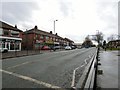
Victoria Avenue
The A6104 through Higher Blackley.
Image: © Gerald England
Taken: 26 Jan 2019
0.10 miles
5
Boothroyden Road
Off Victoria Avenue.
Image: © Gerald England
Taken: 26 Jan 2019
0.11 miles
6
St Clare's RC church and primary school
Image: © Bill Boaden
Taken: 13 Mar 2010
0.11 miles
7
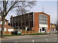
St Clare's Roman Catholic Church
Victoria Avenue, Higher Blackley.
Image: © David Dixon
Taken: 9 Apr 2010
0.12 miles
8
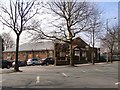
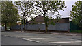
Higher Blackley Royal British Legion Club
Victoria Avenue
Image: © David Dixon
Taken: 9 Apr 2010
0.13 miles
9
Higher Blackley Royal British Legion Club
Image: © Peter McDermott
Taken: 19 May 2020
0.14 miles
10
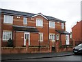
Cecil Road, Blackley, Manchester
Further down Cecil Road is this new block. Although different in style, they have tried to link it with the older houses by adding some lighter brickwork.
Image: © Tricia Neal
Taken: 17 Feb 2014
0.19 miles