IMAGES TAKEN NEAR TO
Gifford Avenue, MANCHESTER, M9 6JH
Introduction
This page details the photographs taken nearby to Gifford Avenue, M9 6JH by members of the Geograph project.
The Geograph project started in 2005 with the aim of publishing, organising and preserving representative images for every square kilometre of Great Britain, Ireland and the Isle of Man.

There are currently over 7.5m images from over14,400 individuals and you can help contribute to the project by visiting https://www.geograph.org.uk
Image Map
Images are licensed for reuse under creativecommons.org/licenses/by-sa/2.0
Notes
- Clicking on the map will re-center to the selected point.
- The higher the marker number, the further away the image location is from the centre of the postcode.
Image Listing (8 Images Found)
Images are licensed for reuse under creativecommons.org/licenses/by-sa/2.0
Image
Details
Distance
1

Victoria Avenue East
The A6104, Victoria Avenue East, at Blackley.
Image: © David Dixon
Taken: 8 Feb 2011
0.13 miles
2
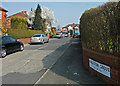
Kingston Grove
This cul-de-sac is off Victoria Avenue East. The houses at the head of the cul-de-sac back onto the M60 motorway.
Image: © michael ely
Taken: 24 Mar 2011
0.14 miles
3
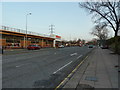
Victoria Avenue, Blackley, Manchester
Image: © Alexander P Kapp
Taken: 12 Jan 2012
0.22 miles
4
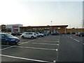
New Tesco at Higher Blackley, Manchester
Image: © Alexander P Kapp
Taken: 12 Jan 2012
0.23 miles
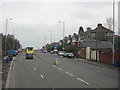
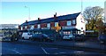
5

Rochdale Road Shops
The shops on Rochdale Road (A664), close to its junction with Victoria Avenue East (A6104), Blackley.
Image: © David Dixon
Taken: 8 Feb 2011
0.24 miles
7
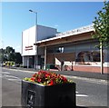
The Avenue Library & Learning Centre
Image: © Anthony Parkes
Taken: 18 Jul 2012
0.25 miles
8
1182 to 1170 Rochdale Road, Blackley
1182 to 1170 on Rochdale Road in Blackley, are commercial premises in north Manchester, England.
Image: © Steven Haslington
Taken: 19 Nov 2013
0.25 miles