IMAGES TAKEN NEAR TO
Gateside Walk, MANCHESTER, M9 6GZ
Introduction
This page details the photographs taken nearby to Gateside Walk, M9 6GZ by members of the Geograph project.
The Geograph project started in 2005 with the aim of publishing, organising and preserving representative images for every square kilometre of Great Britain, Ireland and the Isle of Man.

There are currently over 7.5m images from over14,400 individuals and you can help contribute to the project by visiting https://www.geograph.org.uk
Image Map
Images are licensed for reuse under creativecommons.org/licenses/by-sa/2.0
Notes
- Clicking on the map will re-center to the selected point.
- The higher the marker number, the further away the image location is from the centre of the postcode.
Image Listing (19 Images Found)
Images are licensed for reuse under creativecommons.org/licenses/by-sa/2.0
Image
Details
Distance
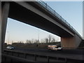
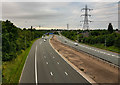
1
M60 Motorway
Junction 20 of the M60 Motorway.
Image: © Peter McDermott
Taken: 17 Oct 2014
0.07 miles
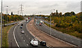
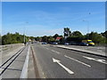
2
M60 Motorway, Junction 20
Looking north west from the bridge on Rochdale Road (A664).
Image: © JThomas
Taken: 25 Sep 2018
0.15 miles
3
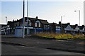
The site of the Chain Bar pub
The pub was never very inviting. A row of shops on Victoria Avenue are behind, on the junction with Hill Lane.
Image: © Bill Boaden
Taken: 21 Apr 2010
0.15 miles
4
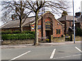
Life Change Community Church, Victoria Avenue
Image: © David Dixon
Taken: 9 Apr 2010
0.15 miles
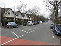
5
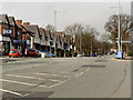
Victoria Avenue
Looking along Victoria Avenue (A6104), towards Higher Blackley.
Image: © David Dixon
Taken: 9 Apr 2010
0.16 miles
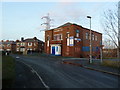
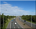
8
Rochdale Road (A664)
Looking north east on the bridge over the M60 Motorway.
Image: © JThomas
Taken: 25 Sep 2018
0.20 miles