IMAGES TAKEN NEAR TO
Linslade Walk, MANCHESTER, M9 5RY
Introduction
This page details the photographs taken nearby to Linslade Walk, M9 5RY by members of the Geograph project.
The Geograph project started in 2005 with the aim of publishing, organising and preserving representative images for every square kilometre of Great Britain, Ireland and the Isle of Man.

There are currently over 7.5m images from over14,400 individuals and you can help contribute to the project by visiting https://www.geograph.org.uk
Image Map
Images are licensed for reuse under creativecommons.org/licenses/by-sa/2.0
Notes
- Clicking on the map will re-center to the selected point.
- The higher the marker number, the further away the image location is from the centre of the postcode.
Image Listing (25 Images Found)
Images are licensed for reuse under creativecommons.org/licenses/by-sa/2.0
Image
Details
Distance
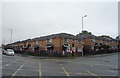
2
The Jolly Miller
Disused public house.
Image: © Peter McDermott
Taken: 2 Sep 2024
0.09 miles
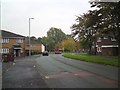
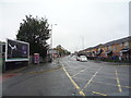
3
Rochdale Road
Buildings on Rochdale Road.
Image: © Peter McDermott
Taken: 17 Oct 2014
0.12 miles
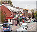
5
Rochdale Road (A664), Manchester
Looking north east.
Image: © JThomas
Taken: 17 Sep 2018
0.13 miles
8
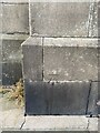
OS Cut Mark - Harpurhey, Christ Church
https://www.bench-marks.org.uk/bm80241
Image: © thejackrustles
Taken: 18 Jul 2022
0.20 miles
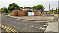
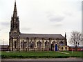
9
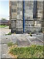
Location of OS Cut Mark - Harpurhey, Christ Church
Image: © thejackrustles
Taken: 18 Jul 2022
0.20 miles
10
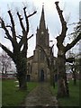
Pollarded trees at Christ Church
The trees alongside the path to the church Image have been heavily pollarded.
Image: © Gerald England
Taken: 1 Apr 2017
0.20 miles