IMAGES TAKEN NEAR TO
Rochdale Road, MANCHESTER, M9 5AS
Introduction
This page details the photographs taken nearby to Rochdale Road, M9 5AS by members of the Geograph project.
The Geograph project started in 2005 with the aim of publishing, organising and preserving representative images for every square kilometre of Great Britain, Ireland and the Isle of Man.

There are currently over 7.5m images from over14,400 individuals and you can help contribute to the project by visiting https://www.geograph.org.uk
Image Map
Images are licensed for reuse under creativecommons.org/licenses/by-sa/2.0
Notes
- Clicking on the map will re-center to the selected point.
- The higher the marker number, the further away the image location is from the centre of the postcode.
Image Listing (29 Images Found)
Images are licensed for reuse under creativecommons.org/licenses/by-sa/2.0
Image
Details
Distance
1
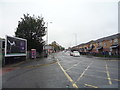
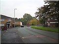
Rochdale Road (A664), Manchester
Looking north east.
Image: © JThomas
Taken: 17 Sep 2018
0.04 miles
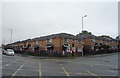
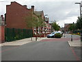
3
Rochdale Road
Buildings on Rochdale Road.
Image: © Peter McDermott
Taken: 17 Oct 2014
0.05 miles
5
Harpurhey, Orchid Street
Part of the Baytree Regeneration Scheme: unfit houses were demolished and surviving houses extended, houses were re-roofed and had solar panels installed, and the area was streetscaped. http://www.manchestereveningnews.co.uk/news/s/115/115869_2m_makeover_for_worst_place_to_live.html
Image: © Mike Faherty
Taken: 29 Aug 2009
0.11 miles
6
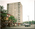
Kingsbridge Court, Harpurhey Road
Kingsbridge Court from Harpurhey Road. The postal address of the block of flats - and of the maisonettes in the foreground - is Kingsbridge Road, yet there is no accessway to Kingsbridge Road!
Image: © Rob K Brettle
Taken: 11 Jun 2000
0.12 miles
7
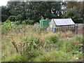
Harpurhey, allotments
Cypress Road Allotments, opposite Image; recently renovated (though not apparent from this picture!). http://www.groundworknw.org.uk/press.asp?action=view&id=202
Image: © Mike Faherty
Taken: 29 Aug 2009
0.13 miles
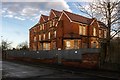
8
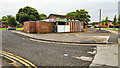
The Jolly Miller
Disused public house.
Image: © Peter McDermott
Taken: 2 Sep 2024
0.13 miles
9
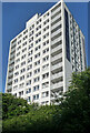
Kingsbridge Court, Kingsbridge Road, Manchester
A thirteen-storey block containing 62 flats which was built around 1963.
Image: © Stephen Richards
Taken: 24 May 2016
0.14 miles