IMAGES TAKEN NEAR TO
Ruthin Avenue, MANCHESTER, M9 0WL
Introduction
This page details the photographs taken nearby to Ruthin Avenue, M9 0WL by members of the Geograph project.
The Geograph project started in 2005 with the aim of publishing, organising and preserving representative images for every square kilometre of Great Britain, Ireland and the Isle of Man.

There are currently over 7.5m images from over14,400 individuals and you can help contribute to the project by visiting https://www.geograph.org.uk
Image Map
Images are licensed for reuse under creativecommons.org/licenses/by-sa/2.0
Notes
- Clicking on the map will re-center to the selected point.
- The higher the marker number, the further away the image location is from the centre of the postcode.
Image Listing (24 Images Found)
Images are licensed for reuse under creativecommons.org/licenses/by-sa/2.0
Image
Details
Distance
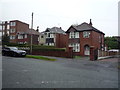
1
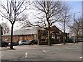
Higher Blackley Royal British Legion Club
Victoria Avenue
Image: © David Dixon
Taken: 9 Apr 2010
0.11 miles
2
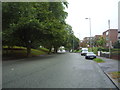
Victoria Avenue, Manchester
Looking north east on the A6104.
Image: © JThomas
Taken: 17 Sep 2018
0.11 miles
3
Higher Blackley Royal British Legion Club
Image: © Peter McDermott
Taken: 19 May 2020
0.11 miles
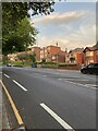
6
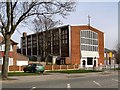
St Clare's Roman Catholic Church
Victoria Avenue, Higher Blackley.
Image: © David Dixon
Taken: 9 Apr 2010
0.13 miles
7
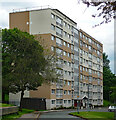
Liverton Court, Liverton Drive, Manchester
A nine-storey slab containing 72 flats which was built around 1970.
Image: © Stephen Richards
Taken: 24 May 2016
0.13 miles
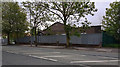
8
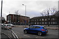
St Clare's RC church and primary school
Image: © Bill Boaden
Taken: 13 Mar 2010
0.15 miles
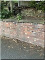
10
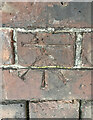
OS Cut Mark: Higher Blackley, Victoria Avenue
https://www.bench-marks.org.uk/bm177086
Image: © thejackrustles
Taken: 19 Jul 2022
0.15 miles