IMAGES TAKEN NEAR TO
Hargrave Close, MANCHESTER, M9 0RU
Introduction
This page details the photographs taken nearby to Hargrave Close, M9 0RU by members of the Geograph project.
The Geograph project started in 2005 with the aim of publishing, organising and preserving representative images for every square kilometre of Great Britain, Ireland and the Isle of Man.

There are currently over 7.5m images from over14,400 individuals and you can help contribute to the project by visiting https://www.geograph.org.uk
Image Map
Images are licensed for reuse under creativecommons.org/licenses/by-sa/2.0
Notes
- Clicking on the map will re-center to the selected point.
- The higher the marker number, the further away the image location is from the centre of the postcode.
Image Listing (7 Images Found)
Images are licensed for reuse under creativecommons.org/licenses/by-sa/2.0
Image
Details
Distance
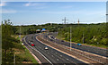
1
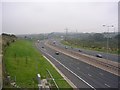
M60 Motorway and Irk Valley
Looking west along the M60 Motorway as it approaches junction 19. The valley of the River Irk runs by the road on the righthand side before the river turns south and passes under the motorway just before junction 19 as seen from here. SD85090488.
Image: © Keith Williamson
Taken: 6 Oct 2005
0.20 miles
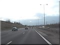
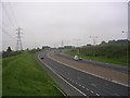
3
M60, Higher Blackley
The "clockwise section" of the Manchester Outer Ring Road (M60), just after junction 19 at Rhodes.
Image: © David Dixon
Taken: 20 Jul 2010
0.23 miles
4
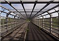
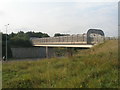
M60
Footbridge over the M60 Motorway.
Image: © Peter McDermott
Taken: 13 May 2018
0.23 miles
5
Footbridge over the M60 south of Rhodes
Image: © John Slater
Taken: 13 Sep 2016
0.23 miles
6
M60 Motorway, Middleton
Looking along the M60 Motorway in an easterly direction from Boothroyden Road footbridge. SD85080495.
Image: © Keith Williamson
Taken: 6 Oct 2005
0.25 miles
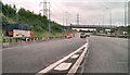
7
M60 Motorway
M60 Motorway at Junction 19.
Image: © Peter McDermott
Taken: 13 May 2018
0.25 miles