IMAGES TAKEN NEAR TO
Finningley Road, MANCHESTER, M9 0QW
Introduction
This page details the photographs taken nearby to Finningley Road, M9 0QW by members of the Geograph project.
The Geograph project started in 2005 with the aim of publishing, organising and preserving representative images for every square kilometre of Great Britain, Ireland and the Isle of Man.

There are currently over 7.5m images from over14,400 individuals and you can help contribute to the project by visiting https://www.geograph.org.uk
Image Map
Images are licensed for reuse under creativecommons.org/licenses/by-sa/2.0
Notes
- Clicking on the map will re-center to the selected point.
- The higher the marker number, the further away the image location is from the centre of the postcode.
Image Listing (14 Images Found)
Images are licensed for reuse under creativecommons.org/licenses/by-sa/2.0
Image
Details
Distance
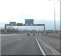
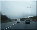
3
M60 Motorway
M60 Motorway at Junction 19.
Image: © Peter McDermott
Taken: 13 May 2018
0.20 miles
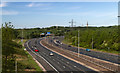
4
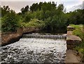
River Irk, near Rhodes
Here the River Irk flows under the M60 motorway. Taken from SD84770483, looking downstream.
Image: © Keith Williamson
Taken: 29 Aug 2005
0.21 miles
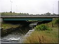
5
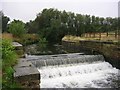
Weir on the River Irk
The River Irk near Rhodes, just before it flows under the M60 Motorway. Looking upstream from SD84770483.
Image: © Keith Williamson
Taken: 29 Aug 2005
0.21 miles
6
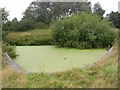
Duckweed!
A duckweed covered, disused reservoir close to the River Irk near Rhodes. A relic of the area's industrial past. Taken from SD84770483.
Image: © Keith Williamson
Taken: 29 Aug 2005
0.21 miles
8

Bus stop on Victoria Avenue (A6104), Manchester
Image: © JThomas
Taken: 17 Sep 2018
0.22 miles
9
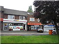
Shop and Dental Practice on Victoria Avenue, Manchester
Image: © JThomas
Taken: 17 Sep 2018
0.24 miles
10
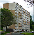
Liverton Court, Liverton Drive, Manchester
A nine-storey slab containing 72 flats which was built around 1970.
Image: © Stephen Richards
Taken: 24 May 2016
0.24 miles