IMAGES TAKEN NEAR TO
Heaton Park Road, MANCHESTER, M9 0QS
Introduction
This page details the photographs taken nearby to Heaton Park Road, M9 0QS by members of the Geograph project.
The Geograph project started in 2005 with the aim of publishing, organising and preserving representative images for every square kilometre of Great Britain, Ireland and the Isle of Man.

There are currently over 7.5m images from over14,400 individuals and you can help contribute to the project by visiting https://www.geograph.org.uk
Image Map
Images are licensed for reuse under creativecommons.org/licenses/by-sa/2.0
Notes
- Clicking on the map will re-center to the selected point.
- The higher the marker number, the further away the image location is from the centre of the postcode.
Image Listing (21 Images Found)
Images are licensed for reuse under creativecommons.org/licenses/by-sa/2.0
Image
Details
Distance

3

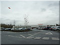
Sainsbury's Heaton Park
This was built on the site of Heaton Mills, which was still operating in the early 1970s. Sainsbury's aren't always sure of the location, in some places referring to it as Manchester or Higher Blackley, but usually it is Heaton Park.
Image: © Bill Boaden
Taken: 5 Feb 2010
0.04 miles
4

Sainsbury's Heaton Park
In the process of being rebuilt.
Image: © Steve Fareham
Taken: 26 May 2011
0.04 miles
5
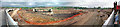
M60 Junction 19 construction May 1995
Panoramic view south from the Middleton Road (A576) bridge over the M60 during construction.
Image: © Simon Harmsworth
Taken: Unknown
0.10 miles
6
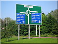
Motorway Junction Sign
This sign post is on the A576 on the approach to Junction 19 of the M60.
Image
This section of the Manchester Outer Ring Road opened to traffic in October 2000.
Image: © Paul Anderson
Taken: 24 Jul 2008
0.14 miles
7
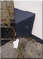
Old Boundary Marker
Municipal Boundary Marker on the northwest side of the former Middleton Road, now a cut off, near its junction with Old Hall Lane, outside the now closed Three Arrows PH. This is on the former boundary between Borough of Manchester and Prestwich UDC, but is now entirely in Manchester metropolitan district. The stone is heavily painted and plastered, but the possible inscriptions are MANCHESTER / BOROUGH and PRESTWICH / UDC.
Milestone Society National ID: LA_MANC01pb
Image: © D Gilbert
Taken: 18 May 2020
0.15 miles
8
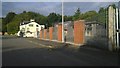
Old Hall Lane, Manchester
A view down Old Hall Lane in the far northeast of the City of Manchester, just by the M60 motorway, and the boundary with Middleton in the Metropolitan Borough of Rochdale. Swarbricks bridal and groom wear shop is behind the fencing.
Image: © Steven Haslington
Taken: 29 Aug 2015
0.15 miles
9

M60 Motorway
The M60 Motorway near Middleton.
Image: © Peter McDermott
Taken: 27 Dec 2014
0.15 miles
10
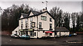
Three Arrows
The Three Arrows public house near Junction 19 of the M60.
Image: © Peter McDermott
Taken: 27 Dec 2014
0.15 miles