IMAGES TAKEN NEAR TO
Brynford Avenue, MANCHESTER, M9 0PA
Introduction
This page details the photographs taken nearby to Brynford Avenue, M9 0PA by members of the Geograph project.
The Geograph project started in 2005 with the aim of publishing, organising and preserving representative images for every square kilometre of Great Britain, Ireland and the Isle of Man.

There are currently over 7.5m images from over14,400 individuals and you can help contribute to the project by visiting https://www.geograph.org.uk
Image Map
Images are licensed for reuse under creativecommons.org/licenses/by-sa/2.0
Notes
- Clicking on the map will re-center to the selected point.
- The higher the marker number, the further away the image location is from the centre of the postcode.
Image Listing (34 Images Found)
Images are licensed for reuse under creativecommons.org/licenses/by-sa/2.0
Image
Details
Distance
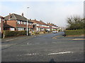
2
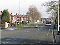
Blackley - Victoria Avenue at Glenbrook Road
Image: © Peter Whatley
Taken: 19 Jan 2011
0.08 miles
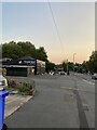
7
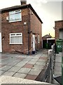
432 Victoria Avenue, Higher Blackley
Image: © thejackrustles
Taken: 19 Jul 2022
0.11 miles
8
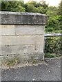
Location of OS Cut Mark - Manchester, Heaton Park Road, New Bridge
Image: © thejackrustles
Taken: 19 Jul 2022
0.16 miles
9
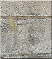
OS Cut Mark - Manchester, Heaton Park Road, New Bridge
https://www.bench-marks.org.uk/bm138945
Image: © thejackrustles
Taken: 19 Jul 2022
0.16 miles
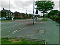
10
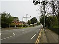
Victoria Avenue
With its average speed enforcement cameras just after crossing the bridge over the River Irk at Higher Blackley
Image: © Kevin Waterhouse
Taken: 8 Sep 2023
0.16 miles