IMAGES TAKEN NEAR TO
Pinfold Lane, MANCHESTER, M90 5YF
Introduction
This page details the photographs taken nearby to Pinfold Lane, M90 5YF by members of the Geograph project.
The Geograph project started in 2005 with the aim of publishing, organising and preserving representative images for every square kilometre of Great Britain, Ireland and the Isle of Man.

There are currently over 7.5m images from over14,400 individuals and you can help contribute to the project by visiting https://www.geograph.org.uk
Image Map
Images are licensed for reuse under creativecommons.org/licenses/by-sa/2.0
Notes
- Clicking on the map will re-center to the selected point.
- The higher the marker number, the further away the image location is from the centre of the postcode.
Image Listing (90 Images Found)
Images are licensed for reuse under creativecommons.org/licenses/by-sa/2.0
Image
Details
Distance
1

No fly zone?
In the present pandemic emergency, Government restrictions have caused the grounding of many aircraft.
Image: © Anthony O'Neil
Taken: 22 Mar 2020
0.03 miles
2
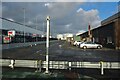
Airport services
On the southwest fringe of Manchester International - still locally referred to as 'Ringway': its name at the time of the second world war and that of the local parish whose church survives nearby.
Image: © Anthony O'Neil
Taken: 10 Feb 2022
0.05 miles
3
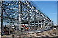
Taller and taller
There is no shortage of structural steel-work on the Manchester Airport complex.
Image: © Anthony O'Neil
Taken: 22 Mar 2020
0.07 miles
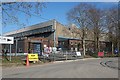
4

Church car park
To the left, the ongoing construction work on Manchester Airport's southern flank.
Image: © Anthony O'Neil
Taken: 22 Mar 2020
0.11 miles
5
Remnants of Wartime
The former Ringway factory of Fairey Aviation (1915) which built and tested a range of fighters and bombers during WWII. The Company went into receivership in the 1950s and its buildings were absorbed into the development of Manchester International Airport.
Image: © Anthony O'Neil
Taken: 22 Mar 2020
0.12 miles
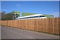
6
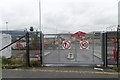
Gate and car park off Pinfold Lane
Part of Manchester Airport. It looks like the car park is being resurfaced.
Image: © Mark Anderson
Taken: 13 Oct 2019
0.13 miles
7
St Mary's Church
In the north east corner of the square
Image: © Chris Shaw
Taken: Unknown
0.13 miles
8
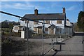
Vicarage Cottages, Ringway
Under reconstruction
Image: © Anthony O'Neil
Taken: 22 Mar 2020
0.13 miles
9
End of the runway
Manchester Airport: this jetliner will not be taking to the air again.
Image: © Anthony O'Neil
Taken: 22 Mar 2020
0.13 miles
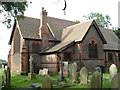
10

Ringway Church (St Mary's)
The first records referring to a ‘Ringway Chapel’ date from 1515 when it was recorded as a chapel of ease in Bowden Parish. The present building, which was consecrated in 1895, closed as a church in 1970 and was used as a storeroom after a new parish church had been built in Hale Barns.
In 1997, the building was restored and converted for use as a design studio by Richard Chadwick Associates Ltd.
Image]
Image: © David Dixon
Taken: 7 Nov 2013
0.14 miles