IMAGES TAKEN NEAR TO
Bury New Road, MANCHESTER, M8 8FW
Introduction
This page details the photographs taken nearby to Bury New Road, M8 8FW by members of the Geograph project.
The Geograph project started in 2005 with the aim of publishing, organising and preserving representative images for every square kilometre of Great Britain, Ireland and the Isle of Man.

There are currently over 7.5m images from over14,400 individuals and you can help contribute to the project by visiting https://www.geograph.org.uk
Image Map (Loading...)


Getting Data...Please wait
Leaflet Map data © OpenStreetMap
Images are licensed for reuse under creativecommons.org/licenses/by-sa/2.0
Notes
- Clicking on the map will re-center to the selected point.
- The higher the marker number, the further away the image location is from the centre of the postcode.
Image Listing (82 Images Found)
Images are licensed for reuse under creativecommons.org/licenses/by-sa/2.0
Image
Details
Distance
1
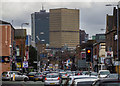
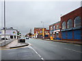
Bury New Road
Bury New Road leading into Manchester City Centre.
Image: © Peter McDermott
Taken: 28 Mar 2016
0.01 miles
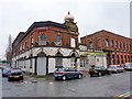
2
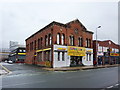
Former church on Bury New Road, Manchester
Image: © Alexander P Kapp
Taken: 10 Jan 2011
0.03 miles
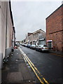
3
Broughton, gurdwara
Gurdwara Sri Harkrishan Sahib Ji, on Sherborne Street.
Image: © Mike Faherty
Taken: 26 Dec 2013
0.03 miles
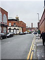
7
Sikh temple, Sherborne Street, Manchester
Image: © Alexander P Kapp
Taken: 10 Jan 2011
0.05 miles
9
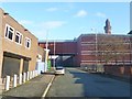
Strangeways, viaduct
Connecting two sections of HMP Manchester over Sherborne Street.
Image: © Mike Faherty
Taken: 26 Dec 2013
0.08 miles
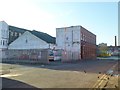
10
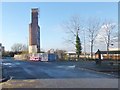
Broughton, disused water tank
On a demolition site in Sherborne Street. The tank bears the name "Overbridge & Springfield Mills".
Image: © Mike Faherty
Taken: 26 Dec 2013
0.08 miles