IMAGES TAKEN NEAR TO
Barrow Hill Road, MANCHESTER, M8 8DB
Introduction
This page details the photographs taken nearby to Barrow Hill Road, M8 8DB by members of the Geograph project.
The Geograph project started in 2005 with the aim of publishing, organising and preserving representative images for every square kilometre of Great Britain, Ireland and the Isle of Man.

There are currently over 7.5m images from over14,400 individuals and you can help contribute to the project by visiting https://www.geograph.org.uk
Image Map (Loading...)


Getting Data...Please wait
Leaflet Map data © OpenStreetMap
Images are licensed for reuse under creativecommons.org/licenses/by-sa/2.0
Notes
- Clicking on the map will re-center to the selected point.
- The higher the marker number, the further away the image location is from the centre of the postcode.
Image Listing (13 Images Found)
Images are licensed for reuse under creativecommons.org/licenses/by-sa/2.0
Image
Details
Distance
1
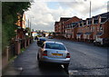
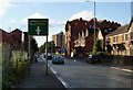
Waterloo Road
This leads down to Lower Broughton. There has been a lot of housing development in this area, much of it social housing. It replaces former commercial land.
Image: © Bill Boaden
Taken: 11 Sep 2010
0.10 miles
2
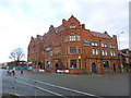
Cheetham, Waterloo Hotel
A grandiose building that might have seen better days - at the corner of Waterloo Road and Elizabeth Street. The pub part has two rooms with central servery; TV, games machines, darts. There remains a fine tiled hallway. At my visit, no cask ale was available.
Update 2022: Stewart Goldwater reports that this building has now been converted into residential flats.
Image: © Mike Faherty
Taken: 26 Dec 2013
0.12 miles
4
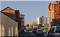
Disused hotel, Waterloo Road, Manchester
Image: © Graham Hogg
Taken: 5 Jul 2010
0.12 miles
5
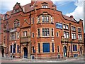
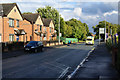
Elizabeth Street
This is approaching the crossroads with Waterloo Road.
Image: © Bill Boaden
Taken: 11 Sep 2010
0.14 miles
6
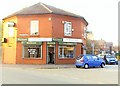
Anderton's Fish & Chip Shop - Higher Broughton
Image: © Anthony Parkes
Taken: 28 Mar 2011
0.18 miles
7

Wash House
Former Wash House on Herbert Street in Cheetham.
Image: © Peter McDermott
Taken: 12 Nov 2016
0.19 miles
8
Ambulance blue-lighting on Elizabeth Street
There was an accident at the junction of Great Cheetham Street and Bury New Road, and I presume it was heading there.
Image: © Bill Boaden
Taken: 11 Sep 2010
0.20 miles
9
Cheetham Children's Centre
In Cheetham Park: http://manchester.fsd.org.uk/kb5/manchester/fsd/organisation.page?record=1GxGklqIZLI
Image: © Mike Faherty
Taken: 26 Dec 2013
0.20 miles
10
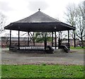
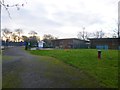
Bandstand, Cheetham Park, Manchester
Cheetham Park, more commonly known as Elizabeth Street Park, is a Victorian park situated at the Cheetham ward of north Manchester. It was opened in 1886 but in recent years it has been neglected and is currently not well used. The bandstand has been a Grade II listed structure since 1994: "Bandstand. c.1890-1910; restored. Cast-iron, wrought-iron and wood, with slate roof. Hexagonal plan. Brick plinth, cast-iron columns, wrought-iron railings bowed in profile, with simple Art Nouveau inverted heart-shape panels, C20 steps at north corner; simple iron brackets to purlins; wooden ribbed and boarded under surface to swept slated canopy roof with apex finial."
Image: © Tricia Neal
Taken: 8 Apr 2014
0.22 miles