IMAGES TAKEN NEAR TO
Turnberry Walk, MANCHESTER, M8 5UA
Introduction
This page details the photographs taken nearby to Turnberry Walk, M8 5UA by members of the Geograph project.
The Geograph project started in 2005 with the aim of publishing, organising and preserving representative images for every square kilometre of Great Britain, Ireland and the Isle of Man.

There are currently over 7.5m images from over14,400 individuals and you can help contribute to the project by visiting https://www.geograph.org.uk
Image Map (Loading...)


Getting Data...Please wait
Leaflet Map data © OpenStreetMap
Images are licensed for reuse under creativecommons.org/licenses/by-sa/2.0
Notes
- Clicking on the map will re-center to the selected point.
- The higher the marker number, the further away the image location is from the centre of the postcode.
Image Listing (19 Images Found)
Images are licensed for reuse under creativecommons.org/licenses/by-sa/2.0
Image
Details
Distance
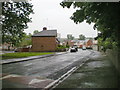
1
St Thomas's Primary School, Lower Crumpsall
Image: © Alexander P Kapp
Taken: 1 May 2009
0.08 miles
2
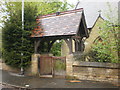
The Parish Church of St Thomas, Lower Crumpsall, Lych gate
Image: © Alexander P Kapp
Taken: 1 May 2009
0.10 miles
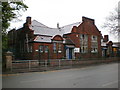
3
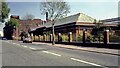
CWS Biscuit Factory
Hazelbottom Road view of the home of the Crumpsall Cream Cracker. Now the works is demolished
Image: © Kevin Waterhouse
Taken: Unknown
0.10 miles
4
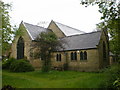
The Parish Church of St Thomas, Lower Crumpsall
Image: © Alexander P Kapp
Taken: 1 May 2009
0.10 miles
5
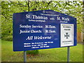
The Parish Church of St Thomas, Lower Crumpsall, Sign
Image: © Alexander P Kapp
Taken: 1 May 2009
0.10 miles
6
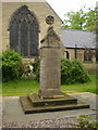
The Parish Church of St Thomas, Lower Crumpsall, War Memorial
Image: © Alexander P Kapp
Taken: 1 May 2009
0.10 miles
7
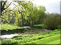
River Irk, Crumpsall, Manchester
This river has its source near Royton, Oldham and joins the River Irwell in central Manchester, near the Cathedral.
Image: © Keith Williamson
Taken: 7 Apr 2005
0.11 miles
8
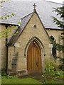
The Parish Church of St Thomas, Lower Crumpsall, Porch
Image: © Alexander P Kapp
Taken: 1 May 2009
0.11 miles
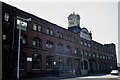
9
CWS Crumpsall Biscuit Factory
View along Hazelbottom Road with the CWS office block and factory beyond. Now all demolished
Image: © Kevin Waterhouse
Taken: Unknown
0.12 miles