IMAGES TAKEN NEAR TO
Bury Old Road, MANCHESTER, M8 5EL
Introduction
This page details the photographs taken nearby to Bury Old Road, M8 5EL by members of the Geograph project.
The Geograph project started in 2005 with the aim of publishing, organising and preserving representative images for every square kilometre of Great Britain, Ireland and the Isle of Man.

There are currently over 7.5m images from over14,400 individuals and you can help contribute to the project by visiting https://www.geograph.org.uk
Image Map
Images are licensed for reuse under creativecommons.org/licenses/by-sa/2.0
Notes
- Clicking on the map will re-center to the selected point.
- The higher the marker number, the further away the image location is from the centre of the postcode.
Image Listing (49 Images Found)
Images are licensed for reuse under creativecommons.org/licenses/by-sa/2.0
Image
Details
Distance
1
Cheetham Precinct, Manchester - 5-5-1996
This precinct and market hall used to roughly occupy the site where the new Tesco/ Costa are located...I recall a cafe, a newsagent, a men's fashion shop etc.
Image: © Duncan Watts
Taken: 5 May 1996
0.01 miles
2
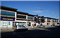
Cheetham Hill shopping precinct
This is a rebuilt version to replace an earlier one on the site.
Image: © Bill Boaden
Taken: 21 Jun 2010
0.01 miles
4
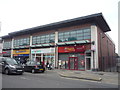
St Margaret's Buildings
The group of shops on Bury Old Road include a Barnardo's charity shop, William Hill bookmakers, Boots pharmacy and Sanam sweethouse and bakery.
Image: © Gerald England
Taken: 5 Dec 2017
0.05 miles
5
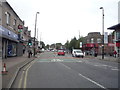
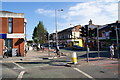
Bury Old Road
Looking north west on the A665.
Image: © JThomas
Taken: 10 Sep 2018
0.06 miles
6
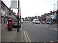
Bury Old Road, Manchester (A665)
Showing position of Postbox No. M8 153.
See Image] for postbox.
Image: © JThomas
Taken: 10 Sep 2018
0.06 miles
7
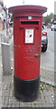
Elizabeth II postbox on Bury Old Road, Manchester
Image: © JThomas
Taken: 10 Sep 2018
0.06 miles
8
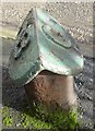
Old Boundary Marker by Bourget Street, Salford
Parish Boundary Marker by the UC road, in parish of Salford (Salford District), Bourget Street, cobbled lane at North end of St Mark's Street, in pavement, behind ornamental gates.
Inscription reads:-
: B / G : (?)
Surveyed
Milestone Society National ID: LA_BROCHE01pb
Image: © Milestone Society
Taken: Unknown
0.06 miles
9
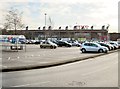
Across Tesco's carpark, Cheetham Hill, Manchester
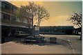
Taken from near to the Memorial Garden, set up in memory of those who were originally buried in the Wesleyan graveyard now covered by the carpark.
Image: © Tricia Neal
Taken: 2 Jan 2014
0.07 miles
10
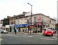
The junction of Crescent Road and Cheetham Hill Road
Cheetham Hill Road is a very long shopping street with a large range of cosmopolitan shops. In the row opposite are Iranian and Polish shops.
Image: © Bill Boaden
Taken: 21 Jun 2010
0.07 miles