IMAGES TAKEN NEAR TO
Rectory Road, MANCHESTER, M8 5EA
Introduction
This page details the photographs taken nearby to Rectory Road, M8 5EA by members of the Geograph project.
The Geograph project started in 2005 with the aim of publishing, organising and preserving representative images for every square kilometre of Great Britain, Ireland and the Isle of Man.

There are currently over 7.5m images from over14,400 individuals and you can help contribute to the project by visiting https://www.geograph.org.uk
Image Map
Images are licensed for reuse under creativecommons.org/licenses/by-sa/2.0
Notes
- Clicking on the map will re-center to the selected point.
- The higher the marker number, the further away the image location is from the centre of the postcode.
Image Listing (91 Images Found)
Images are licensed for reuse under creativecommons.org/licenses/by-sa/2.0
Image
Details
Distance

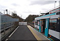
3
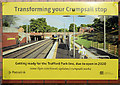
Transforming Crumpsall Metrolink Station
Major upgrade work to upgrade the station began in August 2017 in readiness for the stop to act as the northern terminus for the new six-stop line which is planned to run directly from the Trafford Centre through the city centre and onto the upgraded Crumpsall stop. As well as changes to the existing platforms, the major work involves creating a new entrance from Crumpsall Lane, with both stepped and step-free access. The existing inbound platform is being enlarged to form a new island platform with a turnback facility on the eastern side of the current inbound platform. Northbound trams will be able to return southwards to Manchester city centre from this stop; similar to Shaw and Compton on the Manchester, Oldham and Rochdale line. The new line is scheduled to be operational by 2020.
This poster shows an artist's impression of how the station will appear when the upgrade work has been completed.
Image: © David Dixon
Taken: 11 Mar 2019
0.05 miles
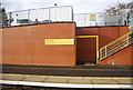
4
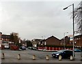
Bennett Road
Bennett Road, Crumpsall viewed from the entrance to the tram station.
Image: © Gerald England
Taken: 18 Feb 2010
0.06 miles
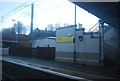
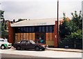
5
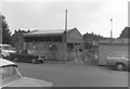
Crumpsall station being rebuilt
Creation of a new booking office was underway, using a standard design widely replicated in the Greater Manchester PTE area.
Image: © Peter Whatley
Taken: Unknown
0.06 miles
6
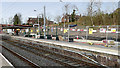
Crumpsall Metrolink Station March 2019
Major upgrade work to upgrade the station began in August 2017 in readiness for the stop to act as the northern terminus for the new six-stop line which is planned to run direct from the Trafford Centre through the city centre and onto the upgraded Crumpsall stop. As well as changes to the existing platforms, the major work involves creating a new entrance from Crumpsall Lane, with both stepped and step free access. The existing inbound platform is being enlarged to form a new island platform with a turnback facility on the eastern side of the current inbound platform. North bound trams will be able to return southwards to Manchester city centre from this stop; similar to Shaw and Compton on the Manchester, Oldham and Rochdale line. The new line is scheduled to be operational by 2020.
Image] shows an artist's impression of how the upgraded station is expected to look when the upgrade has been completed.
Image: © David Dixon
Taken: 11 Mar 2019
0.06 miles
7
Crumpsall station exterior 1988
The relatively new station had been comprehensively vandalised a few days before.
Image: © Peter Whatley
Taken: 8 Oct 1988
0.06 miles