IMAGES TAKEN NEAR TO
Anchor Court, Bury Old Road, MANCHESTER, M8 5DR
Introduction
This page details the photographs taken nearby to Anchor Court, Bury Old Road, M8 5DR by members of the Geograph project.
The Geograph project started in 2005 with the aim of publishing, organising and preserving representative images for every square kilometre of Great Britain, Ireland and the Isle of Man.

There are currently over 7.5m images from over14,400 individuals and you can help contribute to the project by visiting https://www.geograph.org.uk
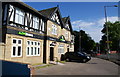
Image Map
Images are licensed for reuse under creativecommons.org/licenses/by-sa/2.0
Notes
- Clicking on the map will re-center to the selected point.
- The higher the marker number, the further away the image location is from the centre of the postcode.
Image Listing (42 Images Found)
Images are licensed for reuse under creativecommons.org/licenses/by-sa/2.0
Image
Details
Distance
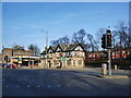
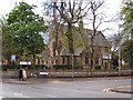
1
Halfway House
A former pub in a landmark position on the crossroads of the A665 and A576. It is now occupied by a firm of solicitors. Beyond it can be seen Bury Old Road where it goes through Cheetham Hill towards Manchester.
Image: © Bill Boaden
Taken: 21 Jun 2010
0.01 miles
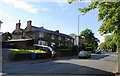
2
Halfway House, 2 Middleton Road, Crumpsall, Manchester
Image: © Alexander P Kapp
Taken: 10 Feb 2008
0.01 miles
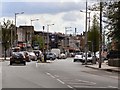
3
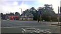
Junction of Bury Old Road and Middleton Road
The road junction of Bury Old Road and Middleton Road, in Manchester, England. This road forms a divide between Broughton in the City of Salford, with Crumpsall in the City of Manchester.
Image: © Steven Haslington
Taken: 29 Aug 2015
0.03 miles
4
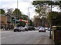
Middleton Road
Middleton Road (A576) approaching the junction with Bury Old Road (A665).
Image: © David Dixon
Taken: 1 May 2010
0.04 miles
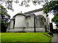
5
Ukrainian Catholic Church
The Ukrainian Catholic Church on Bury Old Road, at the corner of Upper Park Road.
Image: © David Dixon
Taken: 1 May 2010
0.07 miles
6
Back-to-back cottages on Middleton Road
This is not the traditional industrial terrace version, but they nevertheless back on to each other to save space. These have been partly knocked through to make more substantial dwellings.
Image: © Bill Boaden
Taken: 21 Jun 2010
0.09 miles
7
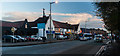
Bury Old Road
The A665 (Bury Old Road) approaching Cheetham Hill.
Image: © David Dixon
Taken: 1 May 2010
0.10 miles
8

Seymour Road
Mr Fix on Seymour Road.
Image: © Peter McDermott
Taken: 1 May 2017
0.11 miles
9
Higher Crumpsall Synagogue
On Bury Old Road
Image: © Kevin Waterhouse
Taken: 29 Aug 2023
0.11 miles
10
Cheetham Hill Village
Bury Old Road at Cheetham Hill Village.
Image: © Peter McDermott
Taken: 22 Nov 2014
0.12 miles