IMAGES TAKEN NEAR TO
Edson Road, MANCHESTER, M8 4WF
Introduction
This page details the photographs taken nearby to Edson Road, M8 4WF by members of the Geograph project.
The Geograph project started in 2005 with the aim of publishing, organising and preserving representative images for every square kilometre of Great Britain, Ireland and the Isle of Man.

There are currently over 7.5m images from over14,400 individuals and you can help contribute to the project by visiting https://www.geograph.org.uk
Image Map
Images are licensed for reuse under creativecommons.org/licenses/by-sa/2.0
Notes
- Clicking on the map will re-center to the selected point.
- The higher the marker number, the further away the image location is from the centre of the postcode.
Image Listing (106 Images Found)
Images are licensed for reuse under creativecommons.org/licenses/by-sa/2.0
Image
Details
Distance
1
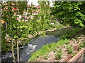
River Irk, Blackley, Manchester
Taken from SD838034, looking upstream.
Image: © Keith Williamson
Taken: 17 May 2005
0.03 miles
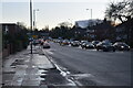
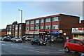
7
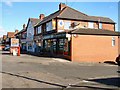
Bowker Vale Post Office
Middleton Road.
Image: © David Dixon
Taken: 11 Mar 2010
0.05 miles
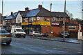
8
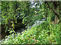
River Irk, Blackley
The River Irk rises to the east of Royton and flows westward through Chadderton, Middleton and Blackley before merging with the River Irwell in the centre of Manchester. This view is looking upstream from Rochbank, in Blackley
Image: © David Dixon
Taken: 7 Jun 2021
0.06 miles