IMAGES TAKEN NEAR TO
Newington Avenue, MANCHESTER, M8 4LT
Introduction
This page details the photographs taken nearby to Newington Avenue, M8 4LT by members of the Geograph project.
The Geograph project started in 2005 with the aim of publishing, organising and preserving representative images for every square kilometre of Great Britain, Ireland and the Isle of Man.

There are currently over 7.5m images from over14,400 individuals and you can help contribute to the project by visiting https://www.geograph.org.uk
Image Map
Images are licensed for reuse under creativecommons.org/licenses/by-sa/2.0
Notes
- Clicking on the map will re-center to the selected point.
- The higher the marker number, the further away the image location is from the centre of the postcode.
Image Listing (97 Images Found)
Images are licensed for reuse under creativecommons.org/licenses/by-sa/2.0
Image
Details
Distance
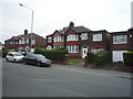
2
Meade Hill Road, Prestwich
Looking north west.
Image: © JThomas
Taken: 10 Sep 2018
0.06 miles
3
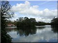
Heaton Park, Manchester
This park is one of the largest municipal parks in Europe and occupies 25% of the green space in Manchester. The photograph shows the boating lake and was taken from SD 830 036
Image: © Keith Williamson
Taken: 12 Apr 2005
0.08 miles
4
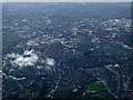
Manchester from the air
The boating lake at Heaton park is in the foreground, with the A576 Middleton Road to its left heading towards the city centre.
Viewed from a Manchester bound flight from Prague.
Image: © Thomas Nugent
Taken: 18 Apr 2014
0.08 miles
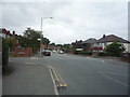
6
Meade Hill Road in Heaton Park, Manchester
Looking north-westward.
Image: © Peter Wood
Taken: 29 Oct 2017
0.09 miles