IMAGES TAKEN NEAR TO
Answell Avenue, MANCHESTER, M8 4GG
Introduction
This page details the photographs taken nearby to Answell Avenue, M8 4GG by members of the Geograph project.
The Geograph project started in 2005 with the aim of publishing, organising and preserving representative images for every square kilometre of Great Britain, Ireland and the Isle of Man.

There are currently over 7.5m images from over14,400 individuals and you can help contribute to the project by visiting https://www.geograph.org.uk
Image Map
Images are licensed for reuse under creativecommons.org/licenses/by-sa/2.0
Notes
- Clicking on the map will re-center to the selected point.
- The higher the marker number, the further away the image location is from the centre of the postcode.
Image Listing (19 Images Found)
Images are licensed for reuse under creativecommons.org/licenses/by-sa/2.0
Image
Details
Distance
1
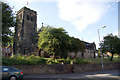
St Matthew's, Crumpsall
Now more correctly known as St Matthew's with St Mary's, following the demise and merger with the former parish of St Mary's along Crumpsall Lane.
Image: © Bill Boaden
Taken: 21 Jun 2010
0.18 miles

3
St Matthew with St Mary Church, Crumpsall, Manchester
Image: © JThomas
Taken: 17 Sep 2018
0.19 miles
5
The Parish Church of St Matthew with St Mary, Crumpsall
Image: © David Dixon
Taken: 30 Apr 2012
0.19 miles
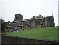
6
St Matthew's Church, Crumpsall
The church of St Matthew with St Mary, Crumpsall.
Image: © David Dixon
Taken: 30 Apr 2012
0.19 miles
7
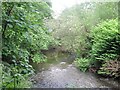
Bowker Bank Woods, Crumpsall, Manchester
This is part of a wooded area near my home which volunteers have recently tidied up and made usable with paths, steps etc. The river is the Irk.
Image: © Tricia Neal
Taken: 15 Jun 2013
0.20 miles
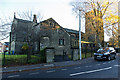
8
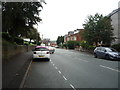
Delaunays Road, Manchester
Looking north east.
Image: © JThomas
Taken: 17 Sep 2018
0.20 miles
9
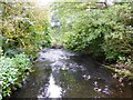
River Irk
Viewed from a footbridge in Bowker Vale
Image: © Kevin Waterhouse
Taken: 8 Sep 2023
0.20 miles
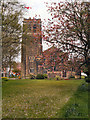
10
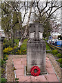
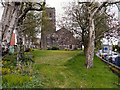
War Memorial and St Matthew's Church
The War Memorial in the grounds of St Matthew's Church (which can be seen behind the memorial, through the trees).
Image: © David Dixon
Taken: 30 Apr 2012
0.20 miles