IMAGES TAKEN NEAR TO
Hurstead Close, MANCHESTER, M8 0QX
Introduction
This page details the photographs taken nearby to Hurstead Close, M8 0QX by members of the Geograph project.
The Geograph project started in 2005 with the aim of publishing, organising and preserving representative images for every square kilometre of Great Britain, Ireland and the Isle of Man.

There are currently over 7.5m images from over14,400 individuals and you can help contribute to the project by visiting https://www.geograph.org.uk
Image Map
Images are licensed for reuse under creativecommons.org/licenses/by-sa/2.0
Notes
- Clicking on the map will re-center to the selected point.
- The higher the marker number, the further away the image location is from the centre of the postcode.
Image Listing (75 Images Found)
Images are licensed for reuse under creativecommons.org/licenses/by-sa/2.0
Image
Details
Distance
1
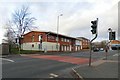
The Collegiate Medical Centre
On Cheetham Hill Road.
Image: © Gerald England
Taken: 29 Dec 2018
0.02 miles
3
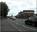
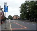
Cheetham Hill Road
The A665 into Manchester.
Image: © Gerald England
Taken: 17 Aug 2009
0.05 miles
4
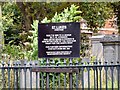
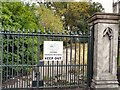
Information on St Luke's
Information board at St Luke's, Cheetham Image
Image: © Gerald England
Taken: 17 Aug 2009
0.06 miles
5
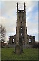
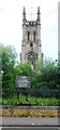
Ruins of St Luke's Church, Cheetham Hill
St Lukes Church was built in 1836 and demolished in the 1980s with the graveyard and tower remaining.The ruins are Grade II listed https://historicengland.org.uk/listing/the-list/list-entry/1293101
Image: © Gerald England
Taken: 29 Dec 2018
0.06 miles
6
Ruins of St Luke's Church, Cheetham Hill
St Lukes Church was built in 1836 and demolished in the 1980s with the graveyard and tower remaining.The ruins are Grade II listed https://historicengland.org.uk/listing/the-list/list-entry/1293101
Image: © Gerald England
Taken: 29 Dec 2018
0.06 miles
7
Japanese Knotweed Treatment
The extensive graveyards at St Luke's Image are closed for Japanese Knotweed Treatment.
Image: © Gerald England
Taken: 17 Aug 2009
0.07 miles
8
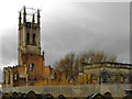
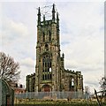
St Luke's Church Tower, Cheetham Hill
Now derelict, St Luke's Church at Cheetham Hill was built in 1836. St Luke’s was a well-known church in the area, and the composer Mendelssohn is reputed to have played the organ here in 1847, the year of his death, when he visited Manchester to give a performance of his 'Elijah' (http://www.lan-opc.org.uk/Manchester/Cheetham/churches.html Lancashire OnLine Parish Clerk Project).
In 1877 St. Luke's was the wealthiest of Manchester's churches and attracted a fashionable congregation but towards the end of the 19th century it began to decline as people moved further from the city centre. Sadly, the church fell into disuse in the 1970s and was partly demolished in the late 1980s. However, the tower remains and is a prominent local landmark; it is currently in the care of The Heritage Trust for the North West.
Here are a couple of photographs showing how it looked before the demolition:
http://www.images.manchester.gov.uk/web/objects/common/webmedia.php?irn=52916
http://www.images.manchester.gov.uk/web/objects/common/webmedia.php?irn=52913
Image: © David Dixon
Taken: 3 Dec 2011
0.07 miles
9
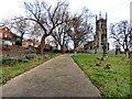
St Luke's
St Luke's at Cheetham Hill.
Image: © Peter McDermott
Taken: 13 Apr 2013
0.07 miles
10
St Luke's - Cheetham
Grade 2 listed Church - Now in the care of the Heritage Trust
Image: © Anthony Parkes
Taken: 19 Jun 2014
0.07 miles