IMAGES TAKEN NEAR TO
Shirley Road, MANCHESTER, M8 0NE
Introduction
This page details the photographs taken nearby to Shirley Road, M8 0NE by members of the Geograph project.
The Geograph project started in 2005 with the aim of publishing, organising and preserving representative images for every square kilometre of Great Britain, Ireland and the Isle of Man.

There are currently over 7.5m images from over14,400 individuals and you can help contribute to the project by visiting https://www.geograph.org.uk
Image Map
Images are licensed for reuse under creativecommons.org/licenses/by-sa/2.0
Notes
- Clicking on the map will re-center to the selected point.
- The higher the marker number, the further away the image location is from the centre of the postcode.
Image Listing (83 Images Found)
Images are licensed for reuse under creativecommons.org/licenses/by-sa/2.0
Image
Details
Distance
4
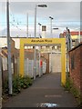
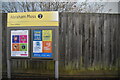
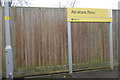
Passenger Access to Abraham Moss Tram Stop
The end of the passage from Woodlands Road to the Abraham Moss tram stop.
Image: © David Dixon
Taken: 17 Oct 2013
0.14 miles
5
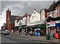
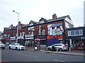
Manchester Super Store - Cheetham Hill Road
Image: © Anthony Parkes
Taken: 19 Jun 2014
0.14 miles
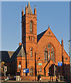
6
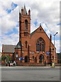
Trinity United Church
At the corner of Greenhill Road and Cheetham Hill Road.
Image: © David Dixon
Taken: 1 May 2010
0.14 miles
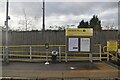
8
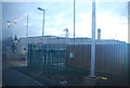
Abraham Moss Station
A new station on the Manchester to Bury Metrolink. It opened in April 2011 and replaced Woodlands Road station.
Image: © N Chadwick
Taken: 17 Dec 2011
0.15 miles