IMAGES TAKEN NEAR TO
Cavendish Road, SALFORD, M7 4WA
Introduction
This page details the photographs taken nearby to Cavendish Road, M7 4WA by members of the Geograph project.
The Geograph project started in 2005 with the aim of publishing, organising and preserving representative images for every square kilometre of Great Britain, Ireland and the Isle of Man.

There are currently over 7.5m images from over14,400 individuals and you can help contribute to the project by visiting https://www.geograph.org.uk
Image Map
Images are licensed for reuse under creativecommons.org/licenses/by-sa/2.0
Notes
- Clicking on the map will re-center to the selected point.
- The higher the marker number, the further away the image location is from the centre of the postcode.
Image Listing (11 Images Found)
Images are licensed for reuse under creativecommons.org/licenses/by-sa/2.0
Image
Details
Distance
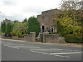
2
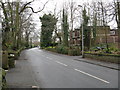
Building Off Singleton Road, Broughton Park
A fine example of the style of dwelling once commonplace in the area.
Image: © Peter Whatley
Taken: 28 Feb 2009
0.09 miles
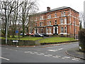
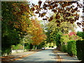
3
Upper Park Road
With the junction with Park Lane behind the camera
Image: © Kevin Waterhouse
Taken: 29 Aug 2023
0.13 miles
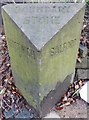
4
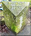
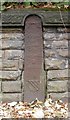
Old Boundary Marker by Singleton Road, Bury Parish
Parish Boundary Marker by the UC road, in parish of Bury (Bury District), Singleton Road, on wide grass at back of footpath outside The Oaks, 76 Singleton Road.
Inscription reads:-
: PRESTWICH : : BOUNDARY / STONE : : SALFORD :
Grade II listed. List Entry Number: 1386168
https://historicengland.org.uk/listing/the-list/list-entry/1386168
Surveyed
Milestone Society National ID: LA_PRESAL01pb.
Image: © Milestone Society
Taken: Unknown
0.14 miles
5
Broughton, synagogue
Holy Law Synagogue on Bury New Road. http://www.manchester2002-uk.com/worship/worship7.html
Image: © Mike Faherty
Taken: 19 Oct 2009
0.15 miles
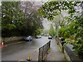
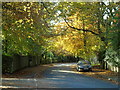
6
Old Hall Road
Taken on Old Hall Road, on my way back towards Singleton Road in Broughton Park, Salford, these colours are about as lovely as I have ever seen in an autumn in this neighbourhood.
Image: © Carroll Pierce
Taken: 21 Oct 2012
0.16 miles
7
Old Hall Road (1)
Old Hall Road at the junction with New Hall Avenue, Broughton Park, Salford, Greater Manchester.
Image: © Carroll Pierce
Taken: 27 Oct 2019
0.19 miles
8
Old Boundary Marker by the A665, Bury Old Road, Salford parish
Parish Boundary Marker by the A665, in parish of Salford (Salford District), Bury Old Road, approx. 25 yards West of cast iron milestone LA_MABYO03 Image and opposite 183 Bury Old Road, Salford.
Inscription reads:-
: PRESTWICH : : BOUNDARY / STONE : : SALFORD :
Grade II listed.
List Entry Number: 1386104 https://historicengland.org.uk/listing/the-list/list-entry/1386104
Surveyed
Milestone Society National ID: LA_MABYO03pb
Image: © Milestone Society
Taken: Unknown
0.19 miles
9
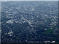
Manchester from the air
Broughton Park is in the foreground, with the distinctive meanders on the River Irwell visible on the right, with the city centre in the centre of the photo.
Viewed from a Manchester bound flight from Prague.
Image: © Thomas Nugent
Taken: 18 Apr 2014
0.20 miles
10
Old Milepost by the A665, Bury Old Road, Salford parish
Cast iron post by the A665, in parish of SALFORD (SALFORD District), Bury Old Road, opposite No. 181, opposite cultural centre, built into wall, on North side of road. St Anne's post (very weathered) erected by the District Council in the 19th century. Approx. 25 yards East of stone Boundary Marker: LA_MABYO03pb Image
Inscription reads:-
TO
ST. ANNES
SQUARE
3
MILES
{coat of arms}
Milestone Society National ID: LA_MABYO03.
Image: © Mike Faherty
Taken: 19 Oct 2009
0.21 miles