IMAGES TAKEN NEAR TO
Park Street, SALFORD, M7 4NJ
Introduction
This page details the photographs taken nearby to Park Street, M7 4NJ by members of the Geograph project.
The Geograph project started in 2005 with the aim of publishing, organising and preserving representative images for every square kilometre of Great Britain, Ireland and the Isle of Man.

There are currently over 7.5m images from over14,400 individuals and you can help contribute to the project by visiting https://www.geograph.org.uk
Image Map
Images are licensed for reuse under creativecommons.org/licenses/by-sa/2.0
Notes
- Clicking on the map will re-center to the selected point.
- The higher the marker number, the further away the image location is from the centre of the postcode.
Image Listing (21 Images Found)
Images are licensed for reuse under creativecommons.org/licenses/by-sa/2.0
Image
Details
Distance
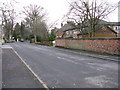
1
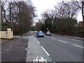
Bury New Road (A56)
Heading towards Manchester.
Image: © JThomas
Taken: 16 Mar 2013
0.07 miles
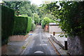
2
New Hall Road (2)
This is New Hall Road, Broughton Park, Salford, Greater Manchester, where it meets Park Lane.
Image: © Carroll Pierce
Taken: 27 Oct 2019
0.07 miles
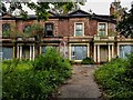
4
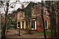
Broughton Park
Derelict houses on Bury New Road at Broughton Park.
See also Image
Image: © Peter McDermott
Taken: 16 Mar 2014
0.13 miles
5
Bury New Road
Derelict house on Bury New Road.
See also Image
Image: © Peter McDermott
Taken: 11 Jun 2020
0.13 miles
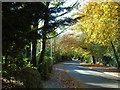
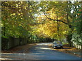
6
Blackfield Lane
A long straight and narrow lane which has been here for a long time.
Image: © Bill Boaden
Taken: 4 Sep 2012
0.15 miles
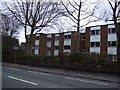
8
Old Hall Road (1)
Old Hall Road at the junction with New Hall Avenue, Broughton Park, Salford, Greater Manchester.
Image: © Carroll Pierce
Taken: 27 Oct 2019
0.16 miles
9
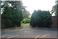
Entrance to Bishopscourt
The residence of the Bishop of Manchester. The view was made difficult by a low sun in the west.
Image: © Bill Boaden
Taken: 4 Sep 2012
0.17 miles
10
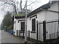
Kersal Bar Toll House, Bury New Road, Salford
On the corner of Moor Lane and Bury Old Road, Kersal, Salford. When I was a student in a nearby hostel, this was a paper shop selling a few food items. Rather than do the 15 minute walk into college for our weekend evening meal, we often bought scones or sausage rolls here to eat in our rooms. It closed some years ago and now stands empty.
A few years ago I discovered it used to be a toll house known as Kersal Bar. When Bury New Road was built in 1831 a gate or bar was erected and travellers had to pay a toll to the turnpike trust to pass through. The toll house had bay window projecting out so that the toll collector had a clear view of the road. By 1848 the local authority had taken over the road and the tolls were abolished. The exterior of the house remains largely unchanged to this day, although it was renovated in 2007 with a two-storey extension being added to the rear. The Toll House is now a Grade II listed building.
Image: © Tricia Neal
Taken: 19 Feb 2014
0.18 miles