IMAGES TAKEN NEAR TO
Bentley Road, SALFORD, M7 4HF
Introduction
This page details the photographs taken nearby to Bentley Road, M7 4HF by members of the Geograph project.
The Geograph project started in 2005 with the aim of publishing, organising and preserving representative images for every square kilometre of Great Britain, Ireland and the Isle of Man.

There are currently over 7.5m images from over14,400 individuals and you can help contribute to the project by visiting https://www.geograph.org.uk
Image Map (Loading...)


Getting Data...Please wait
Leaflet Map data © OpenStreetMap
Images are licensed for reuse under creativecommons.org/licenses/by-sa/2.0
Notes
- Clicking on the map will re-center to the selected point.
- The higher the marker number, the further away the image location is from the centre of the postcode.
Image Listing (20 Images Found)
Images are licensed for reuse under creativecommons.org/licenses/by-sa/2.0
Image
Details
Distance
1
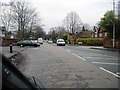
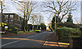
Leicester Road, Salford
Travelling along Leicester Road, towards its junction with Bury Old Road.
Image: © Tricia Neal
Taken: 20 Dec 2013
0.10 miles
2
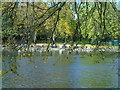
Clowes Park, Salford (3)
This is Clowes Park, Broughton Park, Salford, Greater Manchester, and I am standing on the eastern side of the lake looking towards the children's recreation ground.
Image: © Carroll Pierce
Taken: 27 Oct 2019
0.21 miles
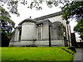
3
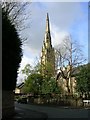
Broughton Park
An affluent residential area of north Salford. This former church has been converted into an apartment complex.
Image: © Keith Williamson
Taken: 12 Apr 2005
0.21 miles
5
Higher Crumpsall Synagogue
On Bury Old Road
Image: © Kevin Waterhouse
Taken: 29 Aug 2023
0.23 miles
6
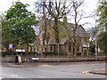
Ukrainian Catholic Church
The Ukrainian Catholic Church on Bury Old Road, at the corner of Upper Park Road.
Image: © David Dixon
Taken: 1 May 2010
0.23 miles
7
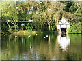
Boat House, Clowes Park
Taken on the east side of the lake in Clowes Park, Broughton Park, Salford.
Image: © Carroll Pierce
Taken: 21 Oct 2012
0.23 miles
8
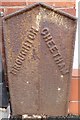
Old Boundary Marker by Japan Street, Salford Parish
Parish Boundary Marker by the UC road, in parish of Salford (Salford District), Japan Street, against front wall of No 10, East side of road.
Inscription reads:- : BROUGHTON : : CHEETHAM :
Surveyed
Milestone Society National ID: LA_BROCHE02pb
Image: © Milestone Society
Taken: Unknown
0.23 miles
9
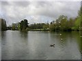
Clowes Park, Salford
Situated within the district of Broughton Park, Salford, Clowes (pronounced like "clues") Park is a surprisingly well maintained park set in an affluent urban area. It is dominated by this attractive lake (where fishing is allowed).
Image: © Keith Williamson
Taken: 12 Apr 2005
0.23 miles
10
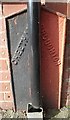
Old Boundary Marker by Japan Street, Salford Parish
Parish Boundary Marker by the UC road, in parish of Salford (Salford District), Japan Street, between front walls of Nos 7 and 9, behind downpipe.
Inscription reads:-
: CHEETHAM : : BROUGHTON :
Surveyed
Milestone Society National ID: LA_BROCHE03pb
Image: © Milestone Society
Taken: Unknown
0.24 miles