IMAGES TAKEN NEAR TO
Leicester Road, SALFORD, M7 4DA
Introduction
This page details the photographs taken nearby to Leicester Road, M7 4DA by members of the Geograph project.
The Geograph project started in 2005 with the aim of publishing, organising and preserving representative images for every square kilometre of Great Britain, Ireland and the Isle of Man.

There are currently over 7.5m images from over14,400 individuals and you can help contribute to the project by visiting https://www.geograph.org.uk
Image Map (Loading...)


Getting Data...Please wait
Leaflet Map data © OpenStreetMap
Images are licensed for reuse under creativecommons.org/licenses/by-sa/2.0
Notes
- Clicking on the map will re-center to the selected point.
- The higher the marker number, the further away the image location is from the centre of the postcode.
Image Listing (26 Images Found)
Images are licensed for reuse under creativecommons.org/licenses/by-sa/2.0
Image
Details
Distance
1
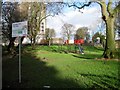
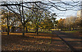
Mandley Park, Salford
The children's play area in Mandley Park.
Image: © Tricia Neal
Taken: 2 Jan 2014
0.07 miles
2
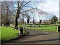
Mandley Park, Salford
A group of exercise machines in the park.
Image: © Tricia Neal
Taken: 2 Jan 2014
0.07 miles
4
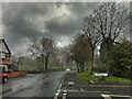
Great Cheetham St East, Broughton
A sudden snowstorm as the unseasonably mild weather that we have been enjoying suddenly changed dramatically to unseasonably cold.
Image: © David Dixon
Taken: 6 Apr 2021
0.15 miles
5
Broughton, Heaton Street
A sudden snowstorm as the unseasonably warm weather changed dramatically to unseasonably cold.
Image: © David Dixon
Taken: 6 Apr 2021
0.16 miles
8
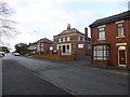
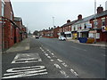
Broughton, college & church
On Tetlow Lane. The premises are shared by Bethel Community College (right) and Bethel Apostolic Ark Church (left). http://www.bethelcomcollege.co.uk/AboutUs.html
Image: © Mike Faherty
Taken: 26 Dec 2013
0.18 miles
10
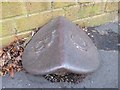
Old Boundary Marker by Tetlow Lane, Salford Parish
Parish Boundary Marker by the UC road, in parish of Salford (Salford District), Tetlow Lane, opposite Great Cheetham Street East in front of college/church in pavement.
Surveyed
Milestone Society National ID: LA_BROCHE04pb
Image: © Milestone Society
Taken: Unknown
0.18 miles