IMAGES TAKEN NEAR TO
Leicester Road, SALFORD, M7 4AS
Introduction
This page details the photographs taken nearby to Leicester Road, M7 4AS by members of the Geograph project.
The Geograph project started in 2005 with the aim of publishing, organising and preserving representative images for every square kilometre of Great Britain, Ireland and the Isle of Man.

There are currently over 7.5m images from over14,400 individuals and you can help contribute to the project by visiting https://www.geograph.org.uk
Image Map (Loading...)


Getting Data...Please wait
Leaflet Map data © OpenStreetMap
Images are licensed for reuse under creativecommons.org/licenses/by-sa/2.0
Notes
- Clicking on the map will re-center to the selected point.
- The higher the marker number, the further away the image location is from the centre of the postcode.
Image Listing (32 Images Found)
Images are licensed for reuse under creativecommons.org/licenses/by-sa/2.0
Image
Details
Distance
5
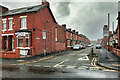
Wellington Street East
Looking east along Wellington Street East from its junction with Tully Street
Image: © Alexander P Kapp
Taken: 12 Aug 2007
0.09 miles
6
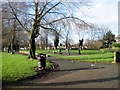
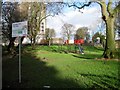
Mandley Park, Salford
A group of exercise machines in the park.
Image: © Tricia Neal
Taken: 2 Jan 2014
0.11 miles
7
Mandley Park, Salford
The children's play area in Mandley Park.
Image: © Tricia Neal
Taken: 2 Jan 2014
0.12 miles
8
Broughton, Heaton Street
A sudden snowstorm as the unseasonably warm weather changed dramatically to unseasonably cold.
Image: © David Dixon
Taken: 6 Apr 2021
0.12 miles