IMAGES TAKEN NEAR TO
Mayfield Road, SALFORD, M7 3WZ
Introduction
This page details the photographs taken nearby to Mayfield Road, M7 3WZ by members of the Geograph project.
The Geograph project started in 2005 with the aim of publishing, organising and preserving representative images for every square kilometre of Great Britain, Ireland and the Isle of Man.

There are currently over 7.5m images from over14,400 individuals and you can help contribute to the project by visiting https://www.geograph.org.uk
Image Map (Loading...)


Getting Data...Please wait
Leaflet Map data © OpenStreetMap
Images are licensed for reuse under creativecommons.org/licenses/by-sa/2.0
Notes
- Clicking on the map will re-center to the selected point.
- The higher the marker number, the further away the image location is from the centre of the postcode.
Image Listing (50 Images Found)
Images are licensed for reuse under creativecommons.org/licenses/by-sa/2.0
Image
Details
Distance
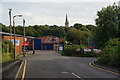
2
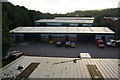
Sedgley Park Trading Estate
Viewed from the Carphone Warehouse car park and looking towards a lowering sun.
Image: © Bill Boaden
Taken: 4 Sep 2012
0.05 miles
3
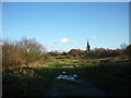
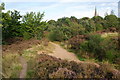
Kersal Moor
Kersal Moor, with St Paul's Church in the background. This is one of the last remaining pieces of open moorland in Salford and has been the site of sporting pursuits (golf, horse-racing), military manoeuvres and public gatherings over the centuries. It is now designated a local nature reserve.
Image: © Carroll Pierce
Taken: 2 Jan 2012
0.08 miles
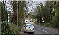
4
St Paul's Road, Kersal
A quiet residential road which leads to a minor access to St Paul's Church. This is looking away from the church.
Image: © Bill Boaden
Taken: 4 Sep 2012
0.08 miles
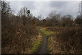
5
Kersal Moor
A surprisingly wild enclave complete with heather. St Paul's, Kersal is showing behind.
Image: © Bill Boaden
Taken: 4 Sep 2012
0.10 miles
6
Sedgley Park Trading Estate
St Paul's, Kersal stands behind.
Image: © Bill Boaden
Taken: 4 Sep 2012
0.10 miles
7
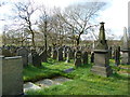
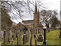
St Paul's Church, Kersal, Graveyard
Image: © Alexander P Kapp
Taken: 3 Apr 2012
0.10 miles
9
St Paul's Church and Graveyard, Kersal Moor
Image: © David Dixon
Taken: 8 Apr 2010
0.10 miles
10
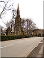
St Paul's Church, Kersal Moor
Viewed from Moor Road.
Image: © David Dixon
Taken: 8 Apr 2010
0.10 miles