IMAGES TAKEN NEAR TO
Patton Court, SALFORD, M7 2NL
Introduction
This page details the photographs taken nearby to Patton Court, M7 2NL by members of the Geograph project.
The Geograph project started in 2005 with the aim of publishing, organising and preserving representative images for every square kilometre of Great Britain, Ireland and the Isle of Man.

There are currently over 7.5m images from over14,400 individuals and you can help contribute to the project by visiting https://www.geograph.org.uk
Image Map (Loading...)


Getting Data...Please wait
Leaflet Map data © OpenStreetMap
Images are licensed for reuse under creativecommons.org/licenses/by-sa/2.0
Notes
- Clicking on the map will re-center to the selected point.
- The higher the marker number, the further away the image location is from the centre of the postcode.
Image Listing (52 Images Found)
Images are licensed for reuse under creativecommons.org/licenses/by-sa/2.0
Image
Details
Distance
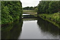
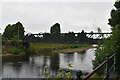
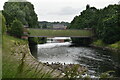
6
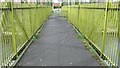
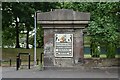
Gerald Road footbridge
Situated where the Broughton Suspension Bridge once was. The original bridge collapsed in 1831, reportedly as a result of troops marching in step.
Image: © Bradley Michael
Taken: 17 Apr 2015
0.06 miles