IMAGES TAKEN NEAR TO
Lower Broughton Road, SALFORD, M7 2HY
Introduction
This page details the photographs taken nearby to Lower Broughton Road, M7 2HY by members of the Geograph project.
The Geograph project started in 2005 with the aim of publishing, organising and preserving representative images for every square kilometre of Great Britain, Ireland and the Isle of Man.

There are currently over 7.5m images from over14,400 individuals and you can help contribute to the project by visiting https://www.geograph.org.uk
Image Map (43 Images)


Getting Data...Please wait
Leaflet Map data © OpenStreetMap
Images are licensed for reuse under creativecommons.org/licenses/by-sa/2.0
Notes
- Clicking on the map will re-center to the selected point.
- The higher the marker number, the further away the image location is from the centre of the postcode.
Image Listing (43 Images Found)
Images are licensed for reuse under creativecommons.org/licenses/by-sa/2.0
Image
Details
Distance
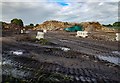
1
Castle Park Care Home
The derelict Castle Park care home in Broughton.
See also Image
Image: © Peter McDermott
Taken: 3 Jan 2022
0.04 miles
2

Castle Park Care Home
The derelict Castle Park care home in Broughton.
Image: © Peter McDermott
Taken: 1 May 2017
0.04 miles
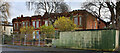
3
High Oldham Drive
Houses on High Oldham Drive.
Image: © Peter McDermott
Taken: 3 Jan 2020
0.11 miles
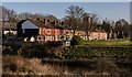
4
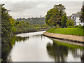
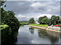
River Irwell, Broughton
The River Irwell, looking upstream from Cromwell Bridge
Image: © David Dixon
Taken: 17 Oct 2010
0.12 miles
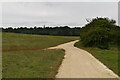
6
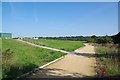
Path Round The Flood Defence
Image: © Glyn Baker
Taken: 31 Aug 2018
0.13 miles
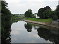
7
The River Irwell from Cromwell Road bridge
Image: © Ian Greig
Taken: 9 Sep 2010
0.14 miles
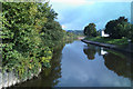
8
River Irwell
Looking north from Cromwell Bridge
Image: © Alexander P Kapp
Taken: 15 Aug 2007
0.15 miles