IMAGES TAKEN NEAR TO
Ilex Grove, SALFORD, M7 2AJ
Introduction
This page details the photographs taken nearby to Ilex Grove, M7 2AJ by members of the Geograph project.
The Geograph project started in 2005 with the aim of publishing, organising and preserving representative images for every square kilometre of Great Britain, Ireland and the Isle of Man.

There are currently over 7.5m images from over14,400 individuals and you can help contribute to the project by visiting https://www.geograph.org.uk
Image Map (Loading...)


Getting Data...Please wait
Leaflet Map data © OpenStreetMap
Images are licensed for reuse under creativecommons.org/licenses/by-sa/2.0
Notes
- Clicking on the map will re-center to the selected point.
- The higher the marker number, the further away the image location is from the centre of the postcode.
Image Listing (41 Images Found)
Images are licensed for reuse under creativecommons.org/licenses/by-sa/2.0
Image
Details
Distance
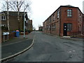
1
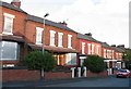
Houses on Bowker Street
Several houses were boarded up.
Image: © Andrew Tatlow
Taken: 2 Sep 2011
0.06 miles
2
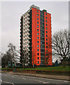
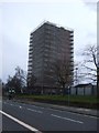
Higher Broughton
Tower block in Higher Broughton.
Image: © Peter McDermott
Taken: 16 Mar 2014
0.07 miles
4
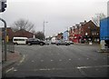
Junction of Bury New Road and Great Cheetham Street, Manchester
The busy junction where the road from Salford crosses the main road between Manchester centre and Bury.
Image: © Tricia Neal
Taken: 20 Dec 2013
0.09 miles
5
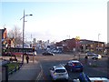
Great Cheetham Street crosses the A56 at Higher Broughton
Image: © Raymond Knapman
Taken: 26 Jan 2012
0.09 miles
6
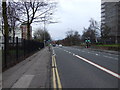
Bury New Road (A56)
Heading south towards Manchester.
Image: © JThomas
Taken: 16 Mar 2013
0.09 miles
8
Back Hilton Street, Broughton, Manchester
Image: © Alexander P Kapp
Taken: 6 Jan 2012
0.11 miles
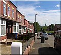
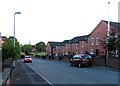
9
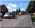
The top end of Bowker Street on a sunny day
Image: © Andrew Tatlow
Taken: 18 Jul 2012
0.11 miles