IMAGES TAKEN NEAR TO
SALFORD, M7 1RY
Introduction
This page details the photographs taken nearby to M7 1RY by members of the Geograph project.
The Geograph project started in 2005 with the aim of publishing, organising and preserving representative images for every square kilometre of Great Britain, Ireland and the Isle of Man.

There are currently over 7.5m images from over14,400 individuals and you can help contribute to the project by visiting https://www.geograph.org.uk
Image Map
Images are licensed for reuse under creativecommons.org/licenses/by-sa/2.0
Notes
- Clicking on the map will re-center to the selected point.
- The higher the marker number, the further away the image location is from the centre of the postcode.
Image Listing (44 Images Found)
Images are licensed for reuse under creativecommons.org/licenses/by-sa/2.0
Image
Details
Distance
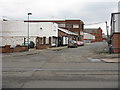
1
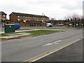
Lower Broughton - Housing Estate Off Great Clowes Street
Image: © Peter Whatley
Taken: 28 Feb 2009
0.07 miles
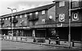
4
Victoria Theatre
Old picturehouse on Great Lower Street.
Image: © Peter McDermott
Taken: 3 Jan 2022
0.12 miles
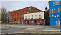
5
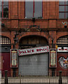
Palace Bingo
The entrance to Palace Bingo, now in a state of disrepair!
Image: © Peter McDermott
Taken: 1 May 2017
0.12 miles
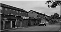
6
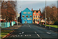
Lower Broughton Road
Lower Broughton Road leading to the junction with Blackfriars Road.
Image: © Peter McDermott
Taken: 31 Dec 2013
0.14 miles
7
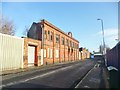
Broughton, boarded-up building
Dated 1920; on Girton Street.
Image: © Mike Faherty
Taken: 26 Dec 2013
0.15 miles
9
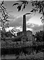
Old Mill
An old Mill Chimney on the bankside of the River Irwell.
Image: © Edward Smith
Taken: 28 Sep 2009
0.17 miles
10
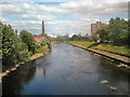
River Irwell
Downstream from Broughton Bridge.
Image: © David Dixon
Taken: 24 Jun 2010
0.17 miles