IMAGES TAKEN NEAR TO
Cedar Place, SALFORD, M7 1NJ
Introduction
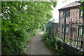
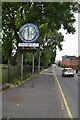
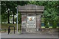
This page details the photographs taken nearby to Cedar Place, M7 1NJ by members of the Geograph project.
The Geograph project started in 2005 with the aim of publishing, organising and preserving representative images for every square kilometre of Great Britain, Ireland and the Isle of Man.

There are currently over 7.5m images from over14,400 individuals and you can help contribute to the project by visiting https://www.geograph.org.uk
Image Map
Images are licensed for reuse under creativecommons.org/licenses/by-sa/2.0
Notes
- Clicking on the map will re-center to the selected point.
- The higher the marker number, the further away the image location is from the centre of the postcode.
Image Listing (67 Images Found)
Images are licensed for reuse under creativecommons.org/licenses/by-sa/2.0
Image
Details
Distance
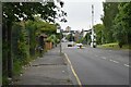
9
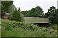
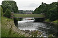
Bridge, Salford
Carries the B6186 over the River Irwell. A sign on the bridge dates it 1880 but doesn't give it a name.
Image: © Graham Hogg
Taken: 5 Jul 2010
0.09 miles