IMAGES TAKEN NEAR TO
Albert Park Road, SALFORD, M7 1LT
Introduction
This page details the photographs taken nearby to Albert Park Road, M7 1LT by members of the Geograph project.
The Geograph project started in 2005 with the aim of publishing, organising and preserving representative images for every square kilometre of Great Britain, Ireland and the Isle of Man.

There are currently over 7.5m images from over14,400 individuals and you can help contribute to the project by visiting https://www.geograph.org.uk
Image Map (24 Images)


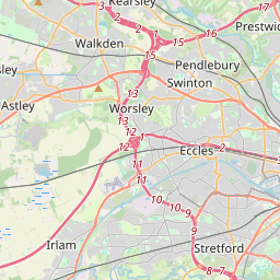

Leaflet Map data © OpenStreetMap
Images are licensed for reuse under creativecommons.org/licenses/by-sa/2.0
Notes
- Clicking on the map will re-center to the selected point.
- The higher the marker number, the further away the image location is from the centre of the postcode.
Image Listing (24 Images Found)
Images are licensed for reuse under creativecommons.org/licenses/by-sa/2.0
Image
Details
Distance
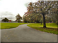

5
Albert Park
Great Cheetham Street West, Broughton.
Image: © David Dixon
Taken: 17 Oct 2010
0.11 miles
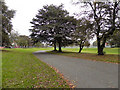
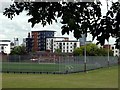
8
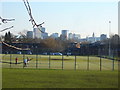
Albert Park Synthetic Pitch
Looking south to the city centre skyline from Albert Park Salford.
Manchester Town Hall visible on the right
Image: © David Seale
Taken: 29 Jan 2006
0.15 miles
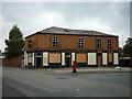
10
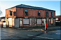
The Carlton
The Carlton public house in Lower Broughton.
Image: © Peter McDermott
Taken: 31 Dec 2013
0.18 miles