IMAGES TAKEN NEAR TO
Water Meadow Lane, SALFORD, M7 1AR
Introduction
This page details the photographs taken nearby to Water Meadow Lane, M7 1AR by members of the Geograph project.
The Geograph project started in 2005 with the aim of publishing, organising and preserving representative images for every square kilometre of Great Britain, Ireland and the Isle of Man.

There are currently over 7.5m images from over14,400 individuals and you can help contribute to the project by visiting https://www.geograph.org.uk
Image Map (Loading...)


Getting Data...Please wait
Leaflet Map data © OpenStreetMap
Images are licensed for reuse under creativecommons.org/licenses/by-sa/2.0
Notes
- Clicking on the map will re-center to the selected point.
- The higher the marker number, the further away the image location is from the centre of the postcode.
Image Listing (36 Images Found)
Images are licensed for reuse under creativecommons.org/licenses/by-sa/2.0
Image
Details
Distance
1
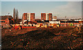
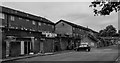
Lower Broughton
Area of redevelopment in Lower Broughton.
Image: © Peter McDermott
Taken: 31 Dec 2013
0.05 miles
2
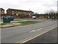
Lower Broughton - Housing Estate Off Great Clowes Street
Image: © Peter Whatley
Taken: 28 Feb 2009
0.10 miles
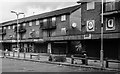
5
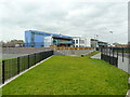
River View Primary School, Lower Broughton
Image: © Alexander P Kapp
Taken: 4 Apr 2012
0.12 miles
6
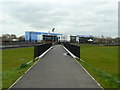
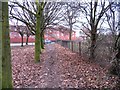
Footpath to River View Primary School, Lower Broughton
Image: © Alexander P Kapp
Taken: 4 Apr 2012
0.12 miles
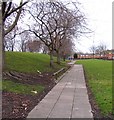
8
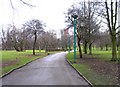
Frederick Road passes the end of a footpath into Peel Park
Image: © Andrew Tatlow
Taken: 18 Feb 2009
0.12 miles
9
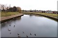
River Irwell by Peel Park
There are substantial flood defences to protect the houses adjacent to the river.
Image: © Andrew Tatlow
Taken: 18 Feb 2009
0.12 miles