IMAGES TAKEN NEAR TO
Meadowgate Road, SALFORD, M6 8EN
Introduction
This page details the photographs taken nearby to Meadowgate Road, M6 8EN by members of the Geograph project.
The Geograph project started in 2005 with the aim of publishing, organising and preserving representative images for every square kilometre of Great Britain, Ireland and the Isle of Man.

There are currently over 7.5m images from over14,400 individuals and you can help contribute to the project by visiting https://www.geograph.org.uk
Image Map
Images are licensed for reuse under creativecommons.org/licenses/by-sa/2.0
Notes
- Clicking on the map will re-center to the selected point.
- The higher the marker number, the further away the image location is from the centre of the postcode.
Image Listing (27 Images Found)
Images are licensed for reuse under creativecommons.org/licenses/by-sa/2.0
Image
Details
Distance
6
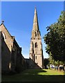
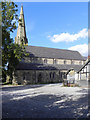
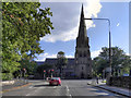
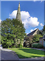
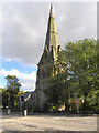
Hope Parish Church
St James (Hope) was built in 1861 in the English Gothic style. The bell tower an spire reaches a height of 160ft.
Image: © Gerald England
Taken: 17 Sep 2016
0.11 miles
8
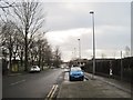
Stott Lane, Salford
This was taken leaving Eccles Old Road and walking along Stott Lane. There is a large carpark ahead on the left, and the road goes on over the motorway towards a Metrolink station.
Image: © Tricia Neal
Taken: 20 Dec 2013
0.12 miles
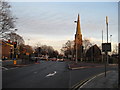
9
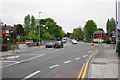
Eccles Old Road
The A576 passing its junction with Tootal Drive.
Image: © Bill Boaden
Taken: 16 May 2016
0.14 miles
10
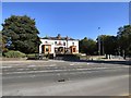
Royal Sovereign
The building was originally the Heath Mount Hotel.
In 1978 Wilson's Brewery, won planning permission to turn it into a pub. Extensions were built and it was renamed The Hope in 1981 and run by Tudor Taverns. Later it became the "Inn of Good Hope" and was owned first by the Swindon-based Tatteshall Castle Group and later the Kent based Free Spirit Group. Following an armed raid in February 2007 it was closed and boarded up.
It finally re-opened as simply "Hope" and was a John Barras pub until 2015 when it became "The Royal Sovereign" and is part of the Burton on Trent based Spirit Pub Company' "Flaming Grill" range .
Image: © Gerald England
Taken: 17 Sep 2016
0.15 miles